1970s Maps of Woodstock, Alabama
Explore 3 historic maps of Woodstock from the 1970s. These maps offer a rare glimpse into what life looked like during the 1970s — showing old roads, neighborhoods, homes, and landmarks that have changed or disappeared over time.
Whether you're researching your family's past, planning a metal detecting trip, or studying how Woodstock's landscape evolved across the 1970s, these high-resolution maps are a powerful tool for exploring the history of this region.
- Focus on a specific era: All maps on this page are from the 1970s, giving you a focused view of this time period.
- See what’s changed: Compare century-old streets, trails, and buildings to today's modern landscape using overlays and satellite layers.
- Research with precision: Use these maps for genealogy, historical research, land use analysis, or educational projects.
- View, download, or print: Maps are fully viewable online in high resolution, and can be downloaded or printed for your own records.
Start exploring Woodstock's history through authentic maps from the 1970s. This is your window into the past.
Woodstock, AL maps
(3)- 1975 Map of Yolande SE, 1977 Print
 1975 Yolande SE1977 Print · USGSJefferson County in the mid-1970s is shown in this detailed orthophoto as industrial patterns and rural settlements meet. Genealogists and local historians can trace the clear physical footprints of Mc Calla, Baylor, and Kimbrell.
 - 1975 Map of Yolande SW, 1977 Print
 1975 Yolande SW1977 Print · USGSTuscaloosa County settlement patterns are captured through high-resolution aerial imagery in the mid-seventies. Researchers can trace the exact footprint of industrial and residential growth near Yolande, Abernant, and Aubrey.
 - 1975 Map of Blocton NE, 1977 Print
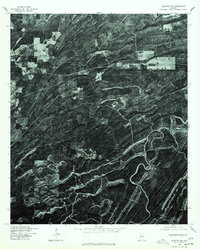 1975 Blocton NE1977 Print · USGSIn the mid-1970s, the terrain of Bibb County was captured in striking detail via this aerial orthophotoquad. You can examine the settlement patterns around Green Pond and trace the timber tracks and ridgelines that define this rural landscape.
End of results
Showing maps 1-3 of 3
Top cities near Woodstock
- Birmingham historical maps
- Tuscaloosa historical maps
- Hoover historical maps
- Bessemer historical maps
- Helena historical maps
- Hueytown historical maps
See more
Top neighborhoods of Woodstock
- Caffee Junction historical maps
- Rickey historical maps
- North Bibb historical maps
- Woodstock Junction historical maps
Frequently asked questions
- What are the different types of historical maps available for Woodstock?
- What is the oldest map of Woodstock?
- Where can I purchase historical maps of Woodstock for my home or office?
- Where can I download high-res historical maps of Woodstock?
- Are there historical topographic maps available for Woodstock?
- Is there historical aerial imagery available for Woodstock?
- Where are historical maps of Woodstock sourced from?