Old Maps of Cold Bay, Alaska for Academic Research
Study the evolution of Cold Bay with 12 high-resolution historic maps. Whether you're teaching, researching, or modeling changes in land use, these maps provide essential visual documentation of urban, environmental, and geographic change.
- Analyze long-term change: Track patterns in development, transportation, and natural features.
- Ideal for environmental or urban studies: Support academic projects with primary historical map data.
- Use in the classroom or lab: Educators and researchers rely on these maps to bring historical context to life.
These maps are a powerful tool for teaching, research, and visualizing how Cold Bay has changed over the decades.
Cold Bay, AK maps
(12)- 1943 Map of Fort Randall, 1954 Print
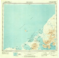 1943 Fort Randall1954 Print · USGSThe Alaska Peninsula and its wartime outposts are documented in this mid-forties survey. Researchers can trace the military footprint at Thornbrough Air Force Base and maritime hubs like King Cove and Belkofski.7 unique versions available
 - 1949 Map of Fort Randall, 1958 Print
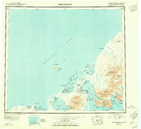
 1949 Fort Randall1958 Print · USGSThe southern Alaska Peninsula and the entrance to the Aleutians are documented here during the late 1940s. Researchers can trace remote coastal outposts like Belkofski, locate the Air Force Base at Fort Randall, and find the abandoned cannery at Morzhovoi Bay.
 - 1950 Map of Fort Randall
 1950 Fort Randall1950 Print · USGSThe Alaska Peninsula at the dawn of the 1950s reveals a rugged landscape of strategic airbases and isolated fishing settlements. Researchers can trace the layout of Thornbrough Air Force Base, find the site of a Cannery (Abandoned), or locate the coastal village of Belkofski.2 unique versions available
 - 1963 Map of Cold Bay B-3, 1967 Print
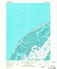 1963 Cold Bay B-31967 Print · USGSThe Aleutian coast meets the Bering Sea in the mid-1960s, showing a landscape defined by protected wetlands and barrier islands. Researchers can trace remote survey markers like Operl NE Base and explore the island chain including Glen Island and Round Island.2 unique versions available
 - 1995 Map of Cold Bay A-2
 1995 Cold Bay A-21995 Print · USGSThe Alaska Peninsula in the mid-nineties shows a landscape of protected wilderness and complex shorelines along the maritime corridor of Cold Bay. Researchers can trace the coastal geography of Old Mans Lagoon, Thinpoint Lake, and the deep waters of Lenard Harbor.
 - 1995 Map of Cold Bay A-3
 1995 Cold Bay A-31995 Print · USGSThe Alaska Peninsula in the mid-nineties is captured here at the remote nexus of the Bering Sea and Pacific. Researchers can trace infrastructure around Cold Bay and Bishop, or locate coastal landmarks like Cape Glazenap and Frosty Peak Glacier.
 - 2020 Map of Cold Bay B-3 SE, 2020 Print
 2020 Cold Bay B-3 SE2020 Print · USGSThe subarctic coastal landscape of the Alaska Peninsula is documented here as it appeared in 2020. Researchers can trace the modern road network including St Louis Road and Pintail Loop Road through a terrain of inland waters like Lake Hess and Blue Bill Lake.
 - 2020 Map of Cold Bay A-3 NW, 2020 Print
 2020 Cold Bay A-3 NW2020 Print · USGSThe Alaska Peninsula appears as a labyrinth of coastal wetlands and tidal inlets in this 2020 survey. Researchers can trace the rugged shoreline from Cape Glazenap to Cove Island and locate the path of Frosty Mountain Road.
 - 2020 Map of Cold Bay A-3 NE, 2020 Print
 2020 Cold Bay A-3 NE2020 Print · USGSCold Bay at the tip of the Alaska Peninsula is shown here as a vital aviation and maritime hub. Researchers can trace local landmarks like the Cold Bay Trout Creek Cem, Livingston Homestead Road, and the airfield at Cold Bay Airport.
 - 2020 Map of Cold Bay A-2 SW, 2020 Print
 2020 Cold Bay A-2 SW2020 Print · USGSThe remote Alaska Peninsula shoreline is captured here as it appeared in 2020, showing a landscape shaped by tidal waters. Researchers can trace the exact coastal boundaries of Old Mans Lagoon, Thinpoint Lake, and Kelp Point.
 - 2020 Map of Cold Bay A-2 NW, 2020 Print
 2020 Cold Bay A-2 NW2020 Print · USGSThe southern Alaska Peninsula comes into focus in the 2020s, showing the intersection of maritime and land routes. Trace the path of the KING COVE ACCESS ROAD past Mortensens Lagoon and the coastal marker at Delta Point.
 - 2020 Map of Cold Bay B-3 SW, 2020 Print
 2020 Cold Bay B-3 SW2020 Print · USGSThe Aleutian East coast is documented here in the early twenty-first century, showcasing the barrier islands and tidal waters of the Alaska Peninsula. Researchers can trace the winding paths of Izembek Slough and the remote reach of Grant Point Road to its end at Grant Point.
End of results
Showing maps 1-12 of 12
Frequently asked questions
- What are the different types of historical maps available for Cold Bay?
- What is the oldest map of Cold Bay?
- Where can I purchase historical maps of Cold Bay for my home or office?
- Where can I download high-res historical maps of Cold Bay?
- Are there historical topographic maps available for Cold Bay?
- Is there historical aerial imagery available for Cold Bay?
- Where are historical maps of Cold Bay sourced from?