1900s (20th Century) Maps of Kantishna, Alaska
Explore 5 historic maps of Kantishna from the 1900s (20th Century). These maps offer a rare glimpse into what life looked like during the 1900s — showing old roads, neighborhoods, homes, and landmarks that have changed or disappeared over time.
Whether you're researching your family's past, planning a metal detecting trip, or studying how Kantishna's landscape evolved across the 1900s, these high-resolution maps are a powerful tool for exploring the history of this region.
- Focus on a specific era: All maps on this page are from the 1900s, giving you a focused view of this time period.
- See what’s changed: Compare century-old streets, trails, and buildings to today's modern landscape using overlays and satellite layers.
- Research with precision: Use these maps for genealogy, historical research, land use analysis, or educational projects.
- View, download, or print: Maps are fully viewable online in high resolution, and can be downloaded or printed for your own records.
Start exploring Kantishna's history through authentic maps from the 1900s. This is your window into the past.
Kantishna, AK maps
(5)- 1952 Map of Mount McKinley
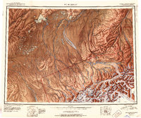 1952 Mount McKinley1952 Print · USGSInterior Alaska in the early fifties shows a landscape of massive glaciers and remote mining outposts. Researchers can trace the legacy of the Stampede Antimony Mine, locate the isolated settlement of Kantishna, and follow the historic Sled Road through the high country.4 unique versions available
 - 1952 Map of Mount McKinley C-2, 1958 Print
 1952 Mount McKinley C-21958 Print · USGSThe Kantishna mining district and the northern edge of the national park are captured here during a period of remote wilderness development. Researchers can trace the early infrastructure of Kantishna, local operations like the Red Top Mine, and the route of the Caribou Trail.2 unique versions available
 - 1954 Map of Mount McKinley C-2, 1969 Print
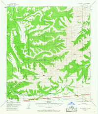 1954 Mount McKinley C-21969 Print · USGSThe Kantishna mining district comes to life in the 1950s, showing the remote camps and trails of interior Alaska before modern development. Genealogists and historians can trace operations at Placer Mines and locate early sites like Busia and Camp Denali.6 unique versions available
 - 1958 Map of Mount McKinley, 1966 Print
 1958 Mount McKinley1966 Print · USGSDenali's towering peaks and the surrounding subarctic wilderness are captured here in the mid-fifties, before the park's later expansion. You can trace early park outposts like Toklat Ranger Sta, the remote settlement at Kantishna, and the isolated Busia Cabin near Wonder Lake.3 unique versions available
 - 1969 Map of Mount McKinley, 1970 Print
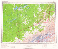
 1969 Mount McKinley1970 Print · USGSThe interior Alaska wilderness appears in the late 1960s, centered on the heights of the Alaska Range and the remote river drainages. Researchers can trace the Winter Trail networks and find early outposts like Kantishna and the Toklat Ranger Sta.
End of results
Showing maps 1-5 of 5
Frequently asked questions
- What are the different types of historical maps available for Kantishna?
- What is the oldest map of Kantishna?
- Where can I purchase historical maps of Kantishna for my home or office?
- Where can I download high-res historical maps of Kantishna?
- Are there historical topographic maps available for Kantishna?
- Is there historical aerial imagery available for Kantishna?
- Where are historical maps of Kantishna sourced from?