Old Maps of Kantishna, Alaska for Hiking & Exploration
Hike through history with 8 historic maps of Kantishna. Explore old trails, ghost towns, and forgotten backroads — perfect for outdoor adventurers and local explorers.
- Rediscover forgotten places: Map out old mining camps, roads, and footpaths that no longer exist on modern maps.
- Layer with modern tools: Combine with LiDAR or satellite views to plan hikes through historical terrain.
- Made for exploration: Popular among hikers, overlanders, and local history lovers.
Use these maps to find adventure and explore the hidden past of Kantishna.
Kantishna, AK maps
(8)- 1952 Map of Mount McKinley
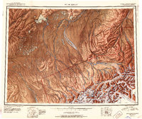 1952 Mount McKinley1952 Print · USGSInterior Alaska in the early fifties shows a landscape of massive glaciers and remote mining outposts. Researchers can trace the legacy of the Stampede Antimony Mine, locate the isolated settlement of Kantishna, and follow the historic Sled Road through the high country.4 unique versions available
 - 1952 Map of Mount McKinley C-2, 1958 Print
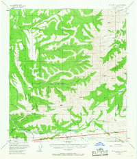
 1952 Mount McKinley C-21958 Print · USGSThe Kantishna mining district and the northern edge of the national park are captured here during a period of remote wilderness development. Researchers can trace the early infrastructure of Kantishna, local operations like the Red Top Mine, and the route of the Caribou Trail.2 unique versions available
 - 1954 Map of Mount McKinley C-2, 1969 Print
 1954 Mount McKinley C-21969 Print · USGSThe Kantishna mining district comes to life in the 1950s, showing the remote camps and trails of interior Alaska before modern development. Genealogists and historians can trace operations at Placer Mines and locate early sites like Busia and Camp Denali.6 unique versions available
 - 1958 Map of Mount McKinley, 1966 Print
 1958 Mount McKinley1966 Print · USGSDenali's towering peaks and the surrounding subarctic wilderness are captured here in the mid-fifties, before the park's later expansion. You can trace early park outposts like Toklat Ranger Sta, the remote settlement at Kantishna, and the isolated Busia Cabin near Wonder Lake.3 unique versions available
 - 1969 Map of Mount McKinley, 1970 Print
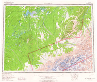
 1969 Mount McKinley1970 Print · USGSThe interior Alaska wilderness appears in the late 1960s, centered on the heights of the Alaska Range and the remote river drainages. Researchers can trace the Winter Trail networks and find early outposts like Kantishna and the Toklat Ranger Sta.
 - 2015 Map of Denali C-2 SW, 2015 Print
 2015 Denali C-2 SW2015 Print · USGSCovers Kantishna, including Denali, United States, and other nearby areas
 - 2019 Map of Denali C-2 SW, 2019 Print
 2019 Denali C-2 SW2019 Print · USGSCovers Kantishna, including Denali, United States, and other nearby areas
 - 2023 Map of Denali C-2 SW, 2023 Print
 2023 Denali C-2 SW2023 Print · USGSDenali National Park and the historic mining district of Kantishna are shown here in the early twenty-first century. Researchers can trace the rugged access routes to remote claims at Upper Canyon via Skyline Drive and the Moose Creek Road Trl.
End of results
Showing maps 1-8 of 8
Frequently asked questions
- What are the different types of historical maps available for Kantishna?
- What is the oldest map of Kantishna?
- Where can I purchase historical maps of Kantishna for my home or office?
- Where can I download high-res historical maps of Kantishna?
- Are there historical topographic maps available for Kantishna?
- Is there historical aerial imagery available for Kantishna?
- Where are historical maps of Kantishna sourced from?