Old Maps of Port Chilkoot, Alaska for Genealogy
Trace your family roots with 6 historic maps of Port Chilkoot. These high-res maps reveal old neighborhoods, homesites, landmarks, and streets — helping you uncover where your ancestors lived and how the area evolved over time.
- Explore historic neighborhoods: Identify where your relatives may have lived in the 1800s or 1900s.
- Compare maps over time: Trace the changes in streets, buildings, and landmarks for multi-generational research.
- Perfect for genealogy & ancestry research: Used by family historians and researchers to map out lineage and migration.
These maps are an incredible resource for exploring your personal connection to Port Chilkoot's past.
Port Chilkoot, AK maps
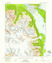
(6)- 1952 Map of Skagway, 1953 Print
 1952 Skagway1953 Print · USGSThe northern reaches of the Alaska Panhandle come alive in the early fifties, showing the vital rail and road links to the Yukon. Trace the historic White Pass & Yukon Route or locate remote camps like Pleasant Camp and Klukwan.4 unique versions available
 - 1954 Map of Skagway A-2, 1959 Print
 1954 Skagway A-21959 Print · USGSSoutheast Alaska in the mid-fifties is defined here by the meeting of massive glaciers and maritime trade routes. Genealogists and historians can trace the early footprints of Haines and Port Chilkoot, locating a Cannery, Landing Field, and local homestead entries.3 unique versions available
 - 1961 Map of Skagway, 1967 Print
 1961 Skagway1967 Print · USGSThe northern reaches of the Panhandle and the rugged border with British Columbia come into focus in the early sixties. Researchers can trace the historic Chilkoot Trail, the White Pass and Yukon Railway, and coastal outposts like Klukwan.4 unique versions available
 - 1991 Map of Skagway A-2 NE
 1991 Skagway A-2 NE1991 Print · USGSCoastal Haines and the surrounding inlets are captured in the early nineties, showing a landscape defined by the sea and historical transit. Researchers can trace the Dalton Trail, locate Fort William H Seward, and study the old settlement of Yindastuki.
 - 2004 Map of Skagway A-2, 2007 Print
 2004 Skagway A-22007 Print · USGSHaines and the Chilkat Peninsula are shown in the mid-2000s, reflecting a landscape defined by massive glaciers and coastal maritime history. Researchers can trace the layout of Port Chilkoot, locate the Yindastuki site, and identify local landmarks like the Letnikof Cove Cannery.
 - 2017 Map of Skagway A-2 NE, 2017 Print
 2017 Skagway A-2 NE2017 Print · USGSThe coastal gateway of Haines and the Chilkat Peninsula are captured here in the late twenty-tens. Researchers can trace local development through the Haines Cem, Haines Airport, and landmarks like Pyramid Island and Port Chilkoot.
End of results
Showing maps 1-6 of 6
Frequently asked questions
- What are the different types of historical maps available for Port Chilkoot?
- What is the oldest map of Port Chilkoot?
- Where can I purchase historical maps of Port Chilkoot for my home or office?
- Where can I download high-res historical maps of Port Chilkoot?
- Are there historical topographic maps available for Port Chilkoot?
- Is there historical aerial imagery available for Port Chilkoot?
- Where are historical maps of Port Chilkoot sourced from?