1940s Maps of Mendenhall Valley, Alaska
Explore 2 historic maps of Mendenhall Valley from the 1940s. These maps offer a rare glimpse into what life looked like during the 1940s — showing old roads, neighborhoods, homes, and landmarks that have changed or disappeared over time.
Whether you're researching your family's past, planning a metal detecting trip, or studying how Mendenhall Valley's landscape evolved across the 1940s, these high-resolution maps are a powerful tool for exploring the history of this region.
- Focus on a specific era: All maps on this page are from the 1940s, giving you a focused view of this time period.
- See what’s changed: Compare century-old streets, trails, and buildings to today's modern landscape using overlays and satellite layers.
- Research with precision: Use these maps for genealogy, historical research, land use analysis, or educational projects.
- View, download, or print: Maps are fully viewable online in high resolution, and can be downloaded or printed for your own records.
Start exploring Mendenhall Valley's history through authentic maps from the 1940s. This is your window into the past.
Mendenhall Valley, AK maps
(2)- 1947 Map of Juneau B-2, 1955 Print
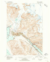 1947 Juneau B-21955 Print · USGSThe industrial waterfront of Juneau and Douglas comes to life in the years following the war. Genealogists and historians can trace mining sites like the Alaska-Juneau Mill, the development of the Juneau Airport, and the early layout of Treadwell.2 unique versions available
 - 1949 Map of Juneau B-2
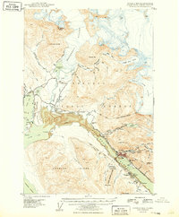 1949 Juneau B-21949 Print · USGSJuneau and Douglas Island appear at a pivotal post-war moment when mining infrastructure and new aviation developments sat side-by-side. Trace the legacy of the gold era through the Alaska Juneau Mill, the Ebner Adit, and the industrial footprint at Treadwell.
End of results
Showing maps 1-2 of 2
Top cities near Mendenhall Valley
Top neighborhoods of Mendenhall Valley
Frequently asked questions
- What are the different types of historical maps available for Mendenhall Valley?
- What is the oldest map of Mendenhall Valley?
- Where can I purchase historical maps of Mendenhall Valley for my home or office?
- Where can I download high-res historical maps of Mendenhall Valley?
- Are there historical topographic maps available for Mendenhall Valley?
- Is there historical aerial imagery available for Mendenhall Valley?
- Where are historical maps of Mendenhall Valley sourced from?