
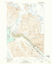
1947 Map of Juneau B-2
USGS Topo · Published 1955About this map
Juneau and the industrial activity of the Gastineau Channel dominate this mid-century topographic record. The landscape shows the significant footprints of the Alaska-Juneau Mill and the Alaska-Juneau Adit, reflecting the mining operations that defined the regional economy. Across the water on Douglas Island, the settlement of Douglas and the site of Treadwell are connected by the historical Treadwell Ditch, while the Juneau Townsite Boundary marks the urban limits of the day.
Find a feature on this map
88 named features on this map. Tap any name to fly to it.
Don’t see what you’re looking for? This feature index may not catch every label — zoom into the map to look around manually.
Map Details
Editions of this 1947 Juneau B-2 Map
2 editions found
Other maps of this area

1947 · Juneau B-3
USGS Topo · 1:63,360

1948 · Juneau A-3
USGS Topo · 1:63,360

1948 · Juneau B-1
USGS Topo · 1:63,360

1949 · Juneau B-3
USGS Topo · 1:62,500

1949 · Juneau B-2
USGS Topo · 1:62,500

1950 · Juneau A-3
USGS Topo · 1:63,360

1951 · Juneau
USGS Topo · 1:250,000

1951 · Juneau A-2
USGS Topo · 1:63,360

1951 · Juneau A-1
USGS Topo · 1:63,360

1951 · Juneau C-3
USGS Topo · 1:63,360