
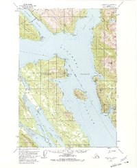
1951 Map of Juneau A-1
USGS Topo · Published 1962About this map
Kuteha Indian Burial Grounds sits along the northern shore of Stephens Passage, marking a significant cultural site near Cherokee Flats. This coastal region south of Juneau is defined by the deep waters of the Taku Inlet and the Gastineau Channel, where the settlement of Dupont stands near the Juneau Townsite Boundary. The map documents a maritime landscape of narrow inlets and high peaks, including Taku Mtn and Butler Peak.
Find a feature on this map
49 named features on this map. Tap any name to fly to it.
Don’t see what you’re looking for? This feature index may not catch every label — zoom into the map to look around manually.
Map Details
Editions of this 1951 Juneau A-1 Map
2 editions found
Other maps of this area

1947 · Juneau B-2
USGS Topo · 1:63,360

1948 · Sitka D-1
USGS Topo · 1:63,360

1948 · Sitka D-2
USGS Topo · 1:63,360

1948 · Sumdum D-6
USGS Topo · 1:63,360

1948 · Juneau B-1
USGS Topo · 1:63,360

1949 · Juneau B-2
USGS Topo · 1:62,500

1951 · Juneau
USGS Topo · 1:250,000

1951 · Taku River B-6
USGS Topo · 1:63,360

1951 · Taku River A-6
USGS Topo · 1:63,360

1951 · Juneau A-2
USGS Topo · 1:63,360