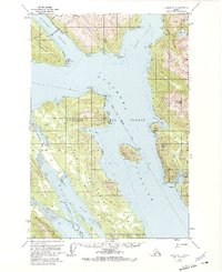
1951 Map of Juneau A-1
USGS Topo · Published 1972About this map
Kutena Indian Burial Grounds on the northern shore of the mainland provides a poignant historical focal point amidst the glacial waters of the Tongass National Forest. This mid-century survey captures the maritime landscape south of Juneau, where the Gastineau Channel meets Stephens Passage. The topography is dominated by the steep rises of Douglas Island and the Glass Peninsula, separated by the deep waters of Seymour Canal. On the eastern shore, Taku Harbor is shown with its Seaplane Base and Taku Harbor settlement, serving as a vital coastal link before the expansion of modern infrastructure. Significant landmarks such as Williams Mountain and the ice-carved basin of Goldstein Gl illustrate the dramatic coastal environment of Southeast Alaska. Cultural fragments like Dupont and various shelter cabins denote a landscape defined by seasonal industry and wilderness navigation.
Find a feature on this map
52 named features on this map. Tap any name to fly to it.
Don’t see what you’re looking for? This feature index may not catch every label — zoom into the map to look around manually.
Map Details
Editions of this 1951 Juneau A-1 Map
2 editions found

Other maps of this area

1947 · Juneau B-2
USGS Topo · 1:63,360

1948 · Sitka D-1
USGS Topo · 1:63,360

1948 · Sitka D-2
USGS Topo · 1:63,360

1948 · Sumdum D-6
USGS Topo · 1:63,360

1948 · Juneau B-1
USGS Topo · 1:63,360

1949 · Juneau B-2
USGS Topo · 1:62,500

1951 · Juneau
USGS Topo · 1:250,000

1951 · Taku River B-6
USGS Topo · 1:63,360

1951 · Taku River A-6
USGS Topo · 1:63,360

1951 · Juneau A-2
USGS Topo · 1:63,360