
1948 Map of Juneau B-1
USGS Topo · Published 1967About this map
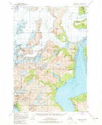
Industrial infrastructure and glacial activity dominate this mid-century view of the mountainous terrain east of the Juneau Townsite Boundary. The landscape is defined by the massive flows of the Taku Glacier and Norris Glacier, which terminate near the silt-laden Ooze Flats and Grizzly Bar. Evidence of early 20th-century resource development is scattered throughout the southern region, specifically around the settlement of Thane and the steep slopes above the Gastineau Channel. An Aerial Tram and several mines underscore the area's mining history, while a Pipe Line runs from a dam at Annex Lakes down to a Power Plant on the shores of Taku Inlet. Further inland, isolated outposts like Portal Camp and Camp No 5 sit among peaks such as Roberts Pk and Middle Pk, marking the reach of human activity into the Tongass National Forest.
Find a feature on this map
51 named features on this map. Tap any name to fly to it.
Don’t see what you’re looking for? This feature index may not catch every label — zoom into the map to look around manually.
Map Details
Editions of this 1948 Juneau B-1 Map
2 editions found
Other maps of this area

1947 · Juneau B-2
USGS Topo · 1:63,360

1949 · Juneau B-2
USGS Topo · 1:62,500

1951 · Juneau
USGS Topo · 1:250,000

1951 · Taku River B-6
USGS Topo · 1:63,360

1951 · Taku River A-6
USGS Topo · 1:63,360

1951 · Juneau A-2
USGS Topo · 1:63,360

1951 · Juneau A-1
USGS Topo · 1:63,360

1952 · Juneau B-1
USGS Topo · 1:63,360

1953 · Taku River
USGS Topo · 1:250,000

1954 · Juneau A-1
USGS Topo · 1:63,360