1980s Maps of Mendenhall Valley, Alaska
Explore 2 historic maps of Mendenhall Valley from the 1980s. These maps offer a rare glimpse into what life looked like during the 1980s — showing old roads, neighborhoods, homes, and landmarks that have changed or disappeared over time.
Whether you're researching your family's past, planning a metal detecting trip, or studying how Mendenhall Valley's landscape evolved across the 1980s, these high-resolution maps are a powerful tool for exploring the history of this region.
- Focus on a specific era: All maps on this page are from the 1980s, giving you a focused view of this time period.
- See what’s changed: Compare century-old streets, trails, and buildings to today's modern landscape using overlays and satellite layers.
- Research with precision: Use these maps for genealogy, historical research, land use analysis, or educational projects.
- View, download, or print: Maps are fully viewable online in high resolution, and can be downloaded or printed for your own records.
Start exploring Mendenhall Valley's history through authentic maps from the 1980s. This is your window into the past.
Mendenhall Valley, AK maps
(2)- 1986 Map of Juneau B-2 SW, 1987 Print
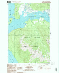 1986 Juneau B-2 SW1987 Print · USGSSoutheast Alaska in the mid-eighties was a landscape of deep channels and towering peaks within the Tongass National Forest. You can trace the drainage of Cropley Lake or locate named summits like Mount Ben Stewart and Saddle Mountain.2 unique versions available
 - 1986 Map of Juneau B-2 NW, 1987 Print
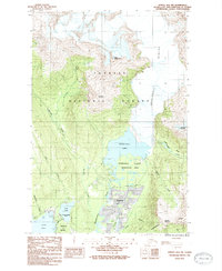 1986 Juneau B-2 NW1987 Print · USGSGreater Juneau in the mid-eighties shows a landscape of glacial retreat and residential expansion near the Mendenhall Valley. Researchers can trace the development of Mendenhaven and the University of Alaska (Juneau) alongside landmarks like Dredge Lake and Auke Lake.2 unique versions available
End of results
Showing maps 1-2 of 2
Top cities near Mendenhall Valley
Top neighborhoods of Mendenhall Valley
Frequently asked questions
- What are the different types of historical maps available for Mendenhall Valley?
- What is the oldest map of Mendenhall Valley?
- Where can I purchase historical maps of Mendenhall Valley for my home or office?
- Where can I download high-res historical maps of Mendenhall Valley?
- Are there historical topographic maps available for Mendenhall Valley?
- Is there historical aerial imagery available for Mendenhall Valley?
- Where are historical maps of Mendenhall Valley sourced from?