Old Maps of Cohoe, Alaska for Hiking & Exploration
Hike through history with 8 historic maps of Cohoe. Explore old trails, ghost towns, and forgotten backroads — perfect for outdoor adventurers and local explorers.
- Rediscover forgotten places: Map out old mining camps, roads, and footpaths that no longer exist on modern maps.
- Layer with modern tools: Combine with LiDAR or satellite views to plan hikes through historical terrain.
- Made for exploration: Popular among hikers, overlanders, and local history lovers.
Use these maps to find adventure and explore the hidden past of Cohoe.
Cohoe, AK maps
(8)- 1944 Map of Kenai, 1954 Print
 1944 Kenai1954 Print · USGSThe Kenai Peninsula and Cook Inlet are captured here during a period of postwar growth, just as the regional road system began to expand. Genealogists and historians can trace early settlements and family landmarks such as Salamatoff, Stelters Ranch, and the Snug Harbor Cannery.4 unique versions available
 - 1950 Map of Kenai
 1950 Kenai1950 Print · USGSThe Kenai Peninsula and Cook Inlet appear here during a pivotal era of mid-century growth and road construction. Researchers can trace the early layout of Soldotna, locate the Snug Harbor Cannery, and see the footprint of Salamatof.2 unique versions available
 - 1951 Map of Kenai B-4, 1967 Print
 1951 Kenai B-41967 Print · USGSThe Kenai Peninsula coastline at the start of the 1950s shows a landscape of fishing settlements and early industrial expansion. Trace the growth of Kalifonsky and Cohoe, or locate historic Gas Wells and the remote Kasilof Landing Strip.2 unique versions available
 - 1952 Map of Kenai B-4, 1954 Print
 1952 Kenai B-41954 Print · USGSThe Kenai Peninsula coastline near Kasilof was a rugged frontier of fishing and homesteading in the early fifties. Genealogists and local historians can trace early settlements at Cohoe, remote Cabins, and the navigation markers at Hongkong Bend.3 unique versions available
 - 1958 Map of Kenai, 1967 Print
 1958 Kenai1967 Print · USGSThe Kenai Peninsula and Cook Inlet are captured here during a period of mid-century growth and wilderness management. Researchers can trace early settlements and infrastructure like Nikishka No 1, Salamatof, and the Wildwood Military Reservation.6 unique versions available
 - 1986 Map of Kenai B-4 SE
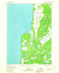
 1986 Kenai B-4 SE1986 Print · USGSThe Kasilof River corridor in the mid-1980s is captured here, showing the balance between early settlement and the vast Kenai National Wildlife Refuge. Genealogists and historians can trace locations around Kasilof, identify local boat ramps, and locate early infrastructure like the Winter Trail.
 - 2014 Map of Kenai B-4 SE, 2014 Print
 2014 Kenai B-4 SE2014 Print · USGSCovers Cohoe, including Kasilof, Kenai Peninsula, and other nearby areas
 - 2024 Map of Kenai B-4 SE, 2024 Print
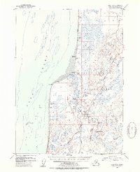
 2024 Kenai B-4 SE2024 Print · USGSThe Kenai Peninsula coastline and riverbanks are captured in this contemporary survey of the settlements between the Sterling Highway and the Cook Inlet. Researchers can locate the Spruce Grove Memorial Cem and trace the winding Kasilof River through Moosehead Rapids and Hongkong Bend.
End of results
Showing maps 1-8 of 8
Top cities near Cohoe
Frequently asked questions
- What are the different types of historical maps available for Cohoe?
- What is the oldest map of Cohoe?
- Where can I purchase historical maps of Cohoe for my home or office?
- Where can I download high-res historical maps of Cohoe?
- Are there historical topographic maps available for Cohoe?
- Is there historical aerial imagery available for Cohoe?
- Where are historical maps of Cohoe sourced from?