Old Maps of Diamond Ridge, Alaska for Hiking & Exploration
Hike through history with 8 historic maps of Diamond Ridge. Explore old trails, ghost towns, and forgotten backroads — perfect for outdoor adventurers and local explorers.
- Rediscover forgotten places: Map out old mining camps, roads, and footpaths that no longer exist on modern maps.
- Layer with modern tools: Combine with LiDAR or satellite views to plan hikes through historical terrain.
- Made for exploration: Popular among hikers, overlanders, and local history lovers.
Use these maps to find adventure and explore the hidden past of Diamond Ridge.
Diamond Ridge, AK maps
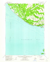
(8)- 1946 Map of Seldovia C-5, 1958 Print
 1946 Seldovia C-51958 Print · USGSThe coastal settlement of Homer and the lower Kenai Peninsula are captured here just after the war as the regional road network began to solidify. Researchers can trace early infrastructure like the Sterling Highway, a shoreline Coal Mine, and the Seaplane Anchorage.
 - 1951 Map of Seldovia C-5
 1951 Seldovia C-51951 Print · USGSThe Kenai Peninsula shoreline comes to life in the early fifties as the southern road system reached toward the sea. Trace the early layout of Homer, the coastal Coal Mine, and landmarks like Ohlson Mtn and Diamond Gulch.
 - 1951 Map of Seldovia, 1952 Print
 1951 Seldovia1952 Print · USGSThe lower Kenai Peninsula appears here in the early fifties as a network of coastal outposts and maritime landing sites. Researchers can trace early settlements like Seldovia, locate family-named points such as Millers Landing, and explore the limits of the Kenai National Moose Range.8 unique versions available
 - 1961 Map of Seldovia C-5, 1962 Print
 1961 Seldovia C-51962 Print · USGSThe Kenai Peninsula shoreline and the burgeoning community of Homer are detailed in the early 1960s. Genealogists and historians can trace early neighborhood roads like Skyline Drive and find local landmarks including Lofgren and the Anchor River Campground.4 unique versions available
 - 1963 Map of Seldovia, 1967 Print
 1963 Seldovia1967 Print · USGSThe lower Kenai Peninsula in the 1960s reveals a rugged coastal frontier where the highway finally meets the sea at Homer. Researchers can trace old settlements and family sites at Happy Valley, Stariski, and the Indian Village near Seldovia.5 unique versions available
 - 1987 Map of Seldovia C-5 NE
 1987 Seldovia C-5 NE1987 Print · USGSThe Kenai Peninsula community of Homer is shown during a period of steady growth in the 1980s, perched between the heights of Diamond Ridge and the waters of Kachemak Bay. Researchers can trace the town's infrastructure from the Radio Tower KBBI to the Beluga Lake seaplane dock and local Cem sites.
 - 2018 Map of Seldovia C-5 NE, 2018 Print
 2018 Seldovia C-5 NE2018 Print · USGSCovers Diamond Ridge, including Homer, Kenai Peninsula, and other nearby areas
 - 2024 Map of Seldovia C-5 NE, 2024 Print
 2024 Seldovia C-5 NE2024 Print · USGSThe Kenai Peninsula coastline comes into focus in this contemporary survey of the area between Homer and Anchor Point. Researchers can trace local development through modern street networks and find essential family history landmarks like the Homer Community Cem and Hickerson Memorial Cem.
End of results
Showing maps 1-8 of 8
Top cities near Diamond Ridge
Frequently asked questions
- What are the different types of historical maps available for Diamond Ridge?
- What is the oldest map of Diamond Ridge?
- Where can I purchase historical maps of Diamond Ridge for my home or office?
- Where can I download high-res historical maps of Diamond Ridge?
- Are there historical topographic maps available for Diamond Ridge?
- Is there historical aerial imagery available for Diamond Ridge?
- Where are historical maps of Diamond Ridge sourced from?