Old Maps of Homer Spit, Homer for Academic Research
Study the evolution of Homer Spit with 8 high-resolution historic maps. Whether you're teaching, researching, or modeling changes in land use, these maps provide essential visual documentation of urban, environmental, and geographic change.
- Analyze long-term change: Track patterns in development, transportation, and natural features.
- Ideal for environmental or urban studies: Support academic projects with primary historical map data.
- Use in the classroom or lab: Educators and researchers rely on these maps to bring historical context to life.
These maps are a powerful tool for teaching, research, and visualizing how Homer Spit has changed over the decades.
Homer Spit, Homer maps
(8)- 1948 Map of Seldovia C-4, 1955 Print
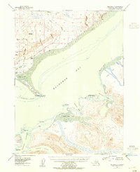 1948 Seldovia C-41955 Print · USGSThe Kachemak Bay coastline comes alive in the mid-1940s, showing the early infrastructure of the Homer area before its modern expansion. Genealogists and researchers can locate old landmarks like Millers Landing, the original Homer Airport, and the Sawmill along the waterfront.2 unique versions available
 - 1949 Map of Seldovia C-4
 1949 Seldovia C-41949 Print · USGSKachemak Bay and the Kenai Peninsula shoreline are captured here in the late 1940s, showing early maritime and aviation development. Trace the origins of local industry and navigation at Millers Landing, the Homer Spit, and the Homer Airport.
 - 1951 Map of Seldovia, 1952 Print
 1951 Seldovia1952 Print · USGSThe lower Kenai Peninsula appears here in the early fifties as a network of coastal outposts and maritime landing sites. Researchers can trace early settlements like Seldovia, locate family-named points such as Millers Landing, and explore the limits of the Kenai National Moose Range.8 unique versions available
 - 1961 Map of Seldovia C-4, 1962 Print
 1961 Seldovia C-41962 Print · USGSThe Kenai Peninsula shoreline and the waters of Kachemak Bay come into sharp focus in the early sixties. You can trace the development of Homer and the Homer Spit, or locate isolated landmarks like the Lighthouse near Halibut Cove.3 unique versions available
 - 1963 Map of Seldovia, 1967 Print
 1963 Seldovia1967 Print · USGSThe lower Kenai Peninsula in the 1960s reveals a rugged coastal frontier where the highway finally meets the sea at Homer. Researchers can trace old settlements and family sites at Happy Valley, Stariski, and the Indian Village near Seldovia.5 unique versions available
 - 1987 Map of Seldovia C-4 SW
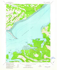
 1987 Seldovia C-4 SW1987 Print · USGSThe coastal waters and islands of the Kenai Peninsula are documented here in the late twentieth century, showing the extension of Homer Spit into Kachemak Bay. Researchers can trace maritime landmarks from Coal Point to Yukon Island and the wilderness boundaries of Kachemak Bay State Park.
 - 2018 Map of Seldovia C-4 SW, 2018 Print
 2018 Seldovia C-4 SW2018 Print · USGSCovers Homer Spit, including Homer, Kenai Peninsula, and other nearby areas
 - 2024 Map of Seldovia C-4 SW, 2024 Print
 2024 Seldovia C-4 SW2024 Print · USGSKachemak Bay and the Kenai Peninsula shoreline are captured here in the early twenty-first century, showing the transition from the docks of Homer to the wild reaches of the southern coast. Trace maritime landmarks like Homer Spit and island trails such as the Grace Ridge Trl.
End of results
Showing maps 1-8 of 8
Frequently asked questions
- What are the different types of historical maps available for Homer Spit?
- What is the oldest map of Homer Spit?
- Where can I purchase historical maps of Homer Spit for my home or office?
- Where can I download high-res historical maps of Homer Spit?
- Are there historical topographic maps available for Homer Spit?
- Is there historical aerial imagery available for Homer Spit?
- Where are historical maps of Homer Spit sourced from?