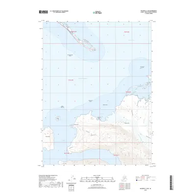
2018 Map of Seldovia C-4 SW
USGS Topo · Published 2018About this map
The Homer Spit extends deep into the waters of Kachemak Bay, serving as a critical terminal for maritime activity and transport at Coal Point. The maritime infrastructure is detailed through the presence of Outer Dock Road and Freight Dock Road, which connect the harbor facilities to the mainland via the Sterling Highway. South of the bay, the landscape transitions into a complex system of islands and glacial valleys, including Yukon Island and the prominent heights of Sadie Knob N and Sadie Knob S. The coastal topography is defined by hazardous navigation points such as the Archimandritof Shoals and Lancashire Rocks. Drainage from the high ridges flows through the Wosnesenski River and Stonehocker Cr, terminating at McKeon Flats along the edge of Neptune Bay.
Find a feature on this map
32 named features on this map. Tap any name to fly to it.
Don’t see what you’re looking for? This feature index may not catch every label — zoom into the map to look around manually.
Map Details
Editions of this 2018 Seldovia C-4 SW Map
This is the sole edition of this map. No revisions or reprints were ever made.
Other maps of this area

1946 · Seldovia C-5
USGS Topo · 1:63,360

1948 · Seldovia C-4
USGS Topo · 1:63,360

1949 · Seldovia C-4
USGS Topo · 1:62,500

1951 · Seldovia C-5
USGS Topo · 1:63,360

1951 · Seldovia
USGS Topo · 1:250,000

1951 · Seldovia B-5
USGS Topo · 1:63,360

1951 · Seldovia B-4
USGS Topo · 1:63,360

1953 · Seldovia B-4
USGS Topo · 1:63,360

1953 · Seldovia B-5
USGS Topo · 1:63,360

1961 · Seldovia C-5
USGS Topo · 1:63,360