1900s (20th Century) Maps of Hope, Alaska
Explore 12 historic maps of Hope from the 1900s (20th Century). These maps offer a rare glimpse into what life looked like during the 1900s — showing old roads, neighborhoods, homes, and landmarks that have changed or disappeared over time.
Whether you're researching your family's past, planning a metal detecting trip, or studying how Hope's landscape evolved across the 1900s, these high-resolution maps are a powerful tool for exploring the history of this region.
- Focus on a specific era: All maps on this page are from the 1900s, giving you a focused view of this time period.
- See what’s changed: Compare century-old streets, trails, and buildings to today's modern landscape using overlays and satellite layers.
- Research with precision: Use these maps for genealogy, historical research, land use analysis, or educational projects.
- View, download, or print: Maps are fully viewable online in high resolution, and can be downloaded or printed for your own records.
Start exploring Hope's history through authentic maps from the 1900s. This is your window into the past.
Hope, AK maps
(12)- 1951 Map of Seward
 1951 Seward1951 Print · USGSThe Kenai Peninsula and Prince William Sound come to life in the early 1950s as the rail and maritime networks linked remote coastal outposts. Genealogists and historians can trace the Alaska Railroad corridor through Seward, find the Jesse Lee Indian School, and locate isolated camps like Latouche and Chenega.4 unique versions available
 - 1951 Map of Seward D-8, 1967 Print
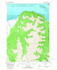 1951 Seward D-81967 Print · USGSThe northern Kenai Peninsula comes into focus in the early 1950s, centered on the mining town of Hope and its surrounding wilderness. Researchers can trace historic claims at the Robinson-Bowman Mine or follow the path of the Ski-Mobile Trail along the bay.2 unique versions available
 - 1951 Map of Seward D-7, 1968 Print
 1951 Seward D-71968 Print · USGSThe northern Kenai Peninsula comes into focus in the early fifties as mining operations and transportation routes defined the rugged interior. Genealogists and historians can trace the foundations of Sunrise and Swetmann Camp or locate the Connolly Mine and Hope Cem.3 unique versions available
 - 1952 Map of Seward D-8, 1954 Print
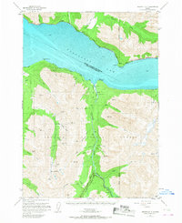
 1952 Seward D-81954 Print · USGSThe settlement at Hope and the surrounding gold-bearing gulches are captured here in the early fifties during a period of wilderness mapping. Historians and researchers can trace the locations of the Robinson Bowman Mine and the Pearson Mine, along with early travel routes like the Ski-Mobile Trail.3 unique versions available
 - 1952 Map of Seward D-7, 1954 Print
 1952 Seward D-71954 Print · USGSThe Kenai Peninsula coastline and its inland mining camps are captured here just after the war, showing the vital transit corridor along the northern shore. Genealogists and historians can locate old burial sites like Sunrise Cemetery and trace the paths to early mining operations such as Swetmann Mine and Downing Mine.3 unique versions available
 - 1953 Map of Seward, 1956 Print
 1953 Seward1956 Print · USGSThe Kenai Peninsula and Prince William Sound are documented in the early 1950s as the rail and road networks expanded. Trace the route of the Alaska Railroad and find early settlements like Seward, Moose Pass, and Latouche.12 unique versions available
 - 1959 Map of Seward
 1959 Seward1959 Print · USGSThe Kenai Peninsula and Prince William Sound are captured here during the mid-century, showing the vital transit corridor between Seward and the interior. Researchers can trace the Alaska Railroad through Whittier and locate historic coastal settlements like Chenega and Latouche.
 - 1984 Map of Seward D-7 NW
 1984 Seward D-7 NW1984 Print · USGSThe northern Kenai Peninsula coast in the mid-eighties shows the critical transport corridor along Turnagain Arm. Researchers can trace the infrastructure of Indian and Bird, and locate landmarks like Windy Point and the RR Br.
 - 1993 Map of Seward D-8 NE
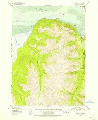
 1993 Seward D-8 NE1993 Print · USGSThe community of Hope and the surrounding Kenai Peninsula shores are shown in the early nineties, revealing a landscape of conservation and resource extraction. Researchers can locate the National Historic District and trace mining activity along Resurrection Creek including tailings and several prospects.
 - 1994 Map of Seward D-8, 1998 Print
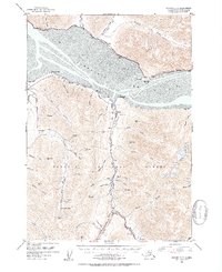
 1994 Seward D-81998 Print · USGSThe Kenai Peninsula near the turn of the millennium remains a landscape of mining heritage and vast wilderness areas. Researchers can trace the proximity of Hope to early-century sites like the Robinson-Bowman Mine and explore the path of the Winter Trail.
 - 1994 Map of Seward D-7, 1998 Print
 1994 Seward D-71998 Print · USGSThe Kenai Peninsula coastline meets the Chugach Mountains in the mid-1990s as the region's mining and maritime history remains etched into the land. Genealogists and historians can locate legacy sites like Sunrise Cemetery, Swetmann Camp, and the Connolly Mine.
 - 1995 Map of Seward D-8, 1999 Print
 1995 Seward D-81999 Print · USGSThe Kenai Peninsula's mining history and coastal wilderness are documented in the mid-nineties, showing the interface of national forest and wildlife refuge lands. You can trace the remnants of the gold era through Historic Mining District Tailings and the Robinson-Bowman Mine south of Hope.
End of results
Showing maps 1-12 of 12
Frequently asked questions
- What are the different types of historical maps available for Hope?
- What is the oldest map of Hope?
- Where can I purchase historical maps of Hope for my home or office?
- Where can I download high-res historical maps of Hope?
- Are there historical topographic maps available for Hope?
- Is there historical aerial imagery available for Hope?
- Where are historical maps of Hope sourced from?