1900s (20th Century) Maps of Kenai, Alaska
Explore 12 historic maps of Kenai from the 1900s (20th Century). These maps offer a rare glimpse into what life looked like during the 1900s — showing old roads, neighborhoods, homes, and landmarks that have changed or disappeared over time.
Whether you're researching your family's past, planning a metal detecting trip, or studying how Kenai's landscape evolved across the 1900s, these high-resolution maps are a powerful tool for exploring the history of this region.
- Focus on a specific era: All maps on this page are from the 1900s, giving you a focused view of this time period.
- See what’s changed: Compare century-old streets, trails, and buildings to today's modern landscape using overlays and satellite layers.
- Research with precision: Use these maps for genealogy, historical research, land use analysis, or educational projects.
- View, download, or print: Maps are fully viewable online in high resolution, and can be downloaded or printed for your own records.
Start exploring Kenai's history through authentic maps from the 1900s. This is your window into the past.
Kenai, AK maps
(12)- 1944 Map of Kenai, 1954 Print
 1944 Kenai1954 Print · USGSThe Kenai Peninsula and Cook Inlet are captured here during a period of postwar growth, just as the regional road system began to expand. Genealogists and historians can trace early settlements and family landmarks such as Salamatoff, Stelters Ranch, and the Snug Harbor Cannery.4 unique versions available
 - 1950 Map of Kenai
 1950 Kenai1950 Print · USGSThe Kenai Peninsula and Cook Inlet appear here during a pivotal era of mid-century growth and road construction. Researchers can trace the early layout of Soldotna, locate the Snug Harbor Cannery, and see the footprint of Salamatof.2 unique versions available
 - 1950 Map of Kenai C-3, 1959 Print
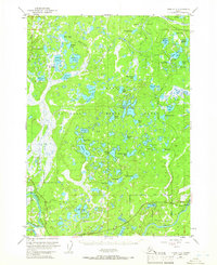
 1950 Kenai C-31959 Print · USGSThe Kenai Peninsula in the early fifties shows a burgeoning wilderness frontier at the dawn of modern settlement. Trace the early layout of Sterling and the Sterling Highway alongside remote landmarks like Mackeys Lakes and the Kenai River.
 - 1951 Map of Kenai C-4, 1965 Print
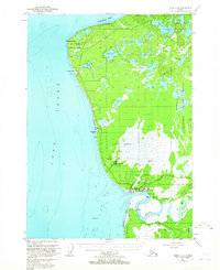 1951 Kenai C-41965 Print · USGSThe Kenai Peninsula coastline comes into focus during the early 1950s as a vital military and industrial corridor. Trace the early development of Kenai and Wildwood Station alongside historical features like the coastal Sawmill, the riverfront Cannery, and Salamatof Beach.3 unique versions available
 - 1951 Map of Kenai C-3, 1966 Print
 1951 Kenai C-31966 Print · USGSThe Kenai Peninsula at the start of the 1950s shows the early growth of Sterling and the industrial activity of the Oil Field. Researchers can trace old transportation routes like the Sterling Highway and find remote landmarks such as the Landing Strip.4 unique versions available
 - 1952 Map of Kenai C-4, 1954 Print
 1952 Kenai C-41954 Print · USGSThe Kenai Peninsula shoreline is captured here in the early fifties as the region's aviation and fishing sectors expanded. Researchers can trace the development of Kenai, locate the East Foreland Lighthouse Reserve, and find now-quiet sites like Salamato (Aband).3 unique versions available
 - 1952 Map of Kenai C-3, 1954 Print
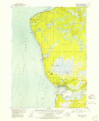
 1952 Kenai C-31954 Print · USGSThe central Kenai Peninsula appears here in the early fifties as the modern road network was first being established. Researchers can trace early settlements at Naptowne and Soldotna or locate primitive cabins along the Kenai River and Whisper Lake.
 - 1958 Map of Kenai, 1967 Print
 1958 Kenai1967 Print · USGSThe Kenai Peninsula and Cook Inlet are captured here during a period of mid-century growth and wilderness management. Researchers can trace early settlements and infrastructure like Nikishka No 1, Salamatof, and the Wildwood Military Reservation.6 unique versions available
 - 1986 Map of Kenai C-4 SE
 1986 Kenai C-4 SE1986 Print · USGSKenai and the surrounding peninsula come into focus during the mid-eighties as the area balanced industrial growth with wildlife preservation. Genealogists and researchers can locate Wildwood, the local Cem, and infrastructure like the Municipal Airport.
 - 1986 Map of Kenai C-4 SW
 1986 Kenai C-4 SW1986 Print · USGSThe eastern shore of the Kenai Peninsula comes into focus during the mid-1980s as local settlements and aviation infrastructure expand along the coast. Researchers can trace the layout of Kenai, the community of Salamatof, and the proximity of the Landing Strip to the waters of Cook Inlet.
 - 1986 Map of Kenai C-3 SW
 1986 Kenai C-3 SW1986 Print · USGSThe Kenai Peninsula in the mid-eighties shows a growing residential and industrial footprint at the interface of wilderness and town. Researchers can trace the development of Kenai and Soldotna, locating features like the Landing Strip, Gas Well sites, and Big Eddy Hole.
 - 1992 Map of Kenai C-3, 2002 Print
 1992 Kenai C-32002 Print · USGSThe Kenai Peninsula at the start of the 1990s shows a complex landscape of oil extraction and conservation. Researchers can trace the development of Sterling and Soldotna or locate specific landmarks like Eagle Rock and the Swanson River Oil Field.
End of results
Showing maps 1-12 of 12
Top cities near Kenai
Frequently asked questions
- What are the different types of historical maps available for Kenai?
- What is the oldest map of Kenai?
- Where can I purchase historical maps of Kenai for my home or office?
- Where can I download high-res historical maps of Kenai?
- Are there historical topographic maps available for Kenai?
- Is there historical aerial imagery available for Kenai?
- Where are historical maps of Kenai sourced from?