Old Maps of Seward, Alaska
Explore 18 old maps of Seward, spanning from 1950 to today. These high-resolution historic maps reveal how streets, neighborhoods, landmarks, and natural features evolved over time — perfect for genealogy, metal detecting, research, and local history exploration.
What you can do with these maps:
- See how Seward changed over time: Compare historical maps to modern-day views to trace roads, homesites, rail lines & more.
- View detailed metadata: Each map includes creators, publishers, year, scale, and archive source.
- Overlay maps with satellite & LiDAR: Visualize the past alongside modern tools to explore terrain & human change.
- Trusted historical sources: Maps sourced from the USGS, Library of Congress, and other archives.
- Access maps your way: View online, download high-res files, or order prints for personal or research use.
Start exploring old maps of Seward to uncover forgotten places, hidden landmarks, and the deep history beneath your feet.
Seward, AK maps
(18)- 1950 Map of Seward A-7, 1976 Print
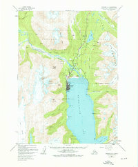 1950 Seward A-71976 Print · USGSSeward and its surrounding fjord-like landscape are captured here at mid-century, just as the port town solidified its role as a rail and maritime hub. Researchers can trace the original rail alignment of the Alaska Railroad, locate the Army Dock, and find early landmarks like Bayview School and the Sawmill.3 unique versions available
 - 1951 Map of Seward
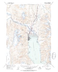
 1951 Seward1951 Print · USGSThe Kenai Peninsula and Prince William Sound come to life in the early 1950s as the rail and maritime networks linked remote coastal outposts. Genealogists and historians can trace the Alaska Railroad corridor through Seward, find the Jesse Lee Indian School, and locate isolated camps like Latouche and Chenega.4 unique versions available
 - 1951 Map of Seward A-7, 1954 Print
 1951 Seward A-71954 Print · USGSSeward and its surrounding mountain peaks are shown here in the early fifties at the terminus of the rail line. Genealogists and historians can trace the Alaska Railroad yard, the Bayview School, and the busy waterfront at Army Dock.4 unique versions available
 - 1953 Map of Seward, 1956 Print
 1953 Seward1956 Print · USGSThe Kenai Peninsula and Prince William Sound are documented in the early 1950s as the rail and road networks expanded. Trace the route of the Alaska Railroad and find early settlements like Seward, Moose Pass, and Latouche.12 unique versions available
 - 1959 Map of Seward
 1959 Seward1959 Print · USGSThe Kenai Peninsula and Prince William Sound are captured here during the mid-century, showing the vital transit corridor between Seward and the interior. Researchers can trace the Alaska Railroad through Whittier and locate historic coastal settlements like Chenega and Latouche.
 - 1983 Map of Seward A-7 SE
 1983 Seward A-7 SE1983 Print · USGSThe eastern coast of the Kenai Peninsula is captured here in the early eighties, showing the town of Seward where it meets the waters of Resurrection Bay. Researchers can trace the drainage of Godwin Glacier and explore the shoreline from Lowell Point to the Thumb Cove inlet.
 - 1983 Map of Seward A-7 NW
 1983 Seward A-7 NW1983 Print · USGSThe Kenai Peninsula's glacial valleys and high peaks are captured here in the early eighties as federal land boundaries were being defined. Trace the wilderness limits of the Kenai Fjords National Monument and landmarks like Mount Benson.
 - 1983 Map of Seward A-7 SW
 1983 Seward A-7 SW1983 Print · USGSSeward and the northeastern edge of the Kenai Fjords are captured in the early eighties as the town sits between the mountains and the sea. Researchers can trace the coastal landscape from Lowell Point to Derby Cove and locate landmarks like Marathon Mountain and the Bear Glacier.
 - 1983 Map of Seward A-7 NE
 1983 Seward A-7 NE1983 Print · USGSSeward and the Resurrection River valley are captured in the early eighties as the coastal hub continued its northern expansion. Researchers can trace the path of the Seward Highway past Woodrow and the waters of Bear Lake toward the icy reaches of the Godwin Glacier.2 unique versions available
 - 1997 Map of Seward A-7, 1999 Print
 1997 Seward A-71999 Print · USGSThe Kenai Peninsula's coastal and rail gateway comes into focus during the late 1990s as it balances industrial growth with conservation. Trace the path of the Alaska Railroad into Seward or locate remote landmarks like the Dale Clemens Cabin and Lowell Point.
 - 2017 Map of Seward A-7 SW, 2017 Print
 2017 Seward A-7 SW2017 Print · USGSCovers Seward, including Kenai Peninsula, United States, and other nearby areas
 - 2017 Map of Seward A-7 SE, 2017 Print
 2017 Seward A-7 SE2017 Print · USGSCovers Seward, including Lowell Point, Kenai Peninsula, and other nearby areas
 - 2018 Map of Seward A-7 NW, 2018 Print
 2018 Seward A-7 NW2018 Print · USGSCovers Seward, including Kenai Peninsula, United States, and other nearby areas
 - 2018 Map of Seward A-7 NE, 2018 Print
 2018 Seward A-7 NE2018 Print · USGSCovers Seward, including Woodrow, Bear Creek, and other nearby areas
 - 2023 Map of Seward A-7 SW, 2023 Print
 2023 Seward A-7 SW2023 Print · USGSSeward and the rugged coast of Resurrection Bay are documented here in the early 2020s, showing the intersection of maritime life and wilderness. Researchers can trace the town’s layout near the Seward Courthouse or follow the shoreline south past Lowell Point to Tonsina Point.
 - 2023 Map of Seward A-7 NE, 2023 Print
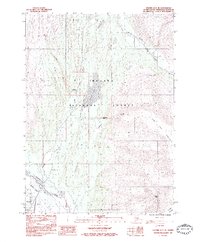
 2023 Seward A-7 NE2023 Print · USGSThe Kenai Peninsula's alpine valleys and the outskirts of Seward are documented here in the early 2020s. Researchers can trace the path of the Iditarod National Historic Trl and locate historic burial grounds like Woodlawn Cem and Masonic Cem.
 - 2023 Map of Seward A-7 NW, 2023 Print
 2023 Seward A-7 NW2023 Print · USGSThe northern reaches of the Kenai Peninsula come into focus here, showing the communities of Seward and Bear Creek as they stand today. Researchers can trace local landmarks like the Pioneers of Alaska Cem or follow the paths of Box Canyon Creek and Herman Lehrer Road.
 - 2023 Map of Seward A-7 SE, 2023 Print
 2023 Seward A-7 SE2023 Print · USGSCoastal Kenai Peninsula comes into focus in this contemporary survey of the area around Seward and Lowell Point. Researchers can trace local roads like Nash Road and Beach Drive alongside shoreline landmarks like Thumb Cove and Caines Head.
End of results
Showing maps 1-18 of 18
Frequently asked questions
- What are the different types of historical maps available for Seward?
- What is the oldest map of Seward?
- Where can I purchase historical maps of Seward for my home or office?
- Where can I download high-res historical maps of Seward?
- Are there historical topographic maps available for Seward?
- Is there historical aerial imagery available for Seward?
- Where are historical maps of Seward sourced from?