Old Maps of Kaguyak, Alaska for Academic Research
Study the evolution of Kaguyak with 3 high-resolution historic maps. Whether you're teaching, researching, or modeling changes in land use, these maps provide essential visual documentation of urban, environmental, and geographic change.
- Analyze long-term change: Track patterns in development, transportation, and natural features.
- Ideal for environmental or urban studies: Support academic projects with primary historical map data.
- Use in the classroom or lab: Educators and researchers rely on these maps to bring historical context to life.
These maps are a powerful tool for teaching, research, and visualizing how Kaguyak has changed over the decades.
Kaguyak, AK maps
(3)- 1951 Map of Afognak C-6, 1956 Print
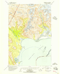 1951 Afognak C-61956 Print · USGSCoastal Alaska in the early fifties shows a landscape of transition where the wilderness of the Katmai National Monument meets the sea. Researchers can trace the locations of former settlements like Kaguyak and Swikshak along the Shelikof Strait.2 unique versions available
 - 1952 Map of Afognak, 1953 Print
 1952 Afognak1953 Print · USGSThe Afognak and Shelikof Strait region in the early fifties shows a remote landscape of maritime outposts and glacier-fed coasts. Researchers can locate coastal settlements like Port William, the Hatchery on Afognak, and the isolated village of Kaguyak.10 unique versions available
 - 2019 Map of Afognak C-6 SW, 2019 Print
 2019 Afognak C-6 SW2019 Print · USGSCoastal Kodiak Island and the eastern reaches of the Katmai wilderness are documented here in the early twenty-first century. Researchers can trace the wild shoreline from Cape Chiniak to the mouth of the Big River along Swikshak Bay.
End of results
Showing maps 1-3 of 3
Frequently asked questions
- What are the different types of historical maps available for Kaguyak?
- What is the oldest map of Kaguyak?
- Where can I purchase historical maps of Kaguyak for my home or office?
- Where can I download high-res historical maps of Kaguyak?
- Are there historical topographic maps available for Kaguyak?
- Is there historical aerial imagery available for Kaguyak?
- Where are historical maps of Kaguyak sourced from?