1951 Map of Afognak C-6
USGS Topo · Published 1956About this map
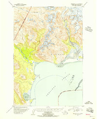
Katmai National Monument dominates the topography of this mid-century survey, its northern boundary roughly following the South Fork Kamishak River as it flows toward the Shelikof Strait. The landscape is defined by the sharp transition from high mountain peaks like VABM 2961 Yak to the coastal tidal flats and lagoons. Along the shoreline, the settlements of Kaguyak and Swikshak are already marked as abandoned, reflecting the displacement of local populations and the shifting focus toward conservation and wilderness management in this part of Alaska. The drainage systems of the Big River and Swikshak River carve through the coastal plain, feeding into Swikshak Lagoon. Off the coast, hazards like Shakun Rock and the Shakun Islets stand out as critical maritime markers near Cape Chiniak.
Find a feature on this map
17 named features on this map. Tap any name to fly to it.
Don’t see what you’re looking for? This feature index may not catch every label — zoom into the map to look around manually.
Map Details
Editions of this 1951 Afognak C-6 Map
2 editions found
Historical Maps of Kaguyak Through Time
335 maps found

1947 Kodiak D-3
Kodiak Island Borough, AK

1949 Kodiak A-3
Kodiak Island Borough, AK

1949 Kodiak B-1 and B-2
Kodiak Island Borough, AK

1949 Kodiak B-3
Kodiak Island Borough, AK

1949 Kodiak C-1
Kodiak Island Borough, AK

1949 Kodiak C-2
Kodiak Island Borough, AK

1949 Kodiak D-1
Kodiak Island Borough, AK

1949 Kodiak D-2
Kodiak Island Borough, AK

1949 Kodiak D-3
Kodiak Island Borough, AK

1950 Kodiak A-3
Kodiak Island Borough, AK

1950 Kodiak B-3
Kodiak Island Borough, AK

1950 Kodiak D-3
Kodiak Island Borough, AK

1951 Afognak C-5
Kodiak Island Borough, AK

1951 Afognak C-6
Kodiak Island Borough, AK

1951 Afognak D-1
Kodiak Island Borough, AK

1951 Kaguyak
Kodiak Island Borough, AK

1951 Karluk C-4 and C-5
Kodiak Island Borough, AK

1951 Karluk C-6
Kodiak Island Borough, AK

1951 Karluk D-4
Kodiak Island Borough, AK

1951 Kodiak B-1 and B-2
Kodiak Island Borough, AK

1951 Kodiak C-1
Kodiak Island Borough, AK

1951 Kodiak D-1
Kodiak Island Borough, AK

1951 Kodiak D-2
Kodiak Island Borough, AK

1951 Kodiak D-6
Kodiak Island Borough, AK

1951 Mount Katmai A-1
Kodiak Island Borough, AK

1951 Mount Katmai A-3
Kodiak Island Borough, AK

1951 Mount Katmai B-1
Kodiak Island Borough, AK

1951 Mount Katmai C-1
Kodiak Island Borough, AK

1951 Mt. Katmai A-2
Kodiak Island Borough, AK

1951 Mt. Katmai A-4
Kodiak Island Borough, AK

1951 Mt. Katmai B-2
Kodiak Island Borough, AK

1951 Trinity Islands
Kodiak Island Borough, AK

1951 Ugashik B-1
Kodiak Island Borough, AK

1951 Ugashik B-2
Kodiak Island Borough, AK

1952 Afognak A-0 and B-0
Kodiak Island Borough, AK

1952 Afognak A-1
Kodiak Island Borough, AK

1952 Afognak A-2
Kodiak Island Borough, AK

1952 Afognak A-3
Kodiak Island Borough, AK

1952 Afognak A-4
Kodiak Island Borough, AK

1952 Afognak A-5
Kodiak Island Borough, AK

1952 Afognak B-1
Kodiak Island Borough, AK

1952 Afognak B-2
Kodiak Island Borough, AK

1952 Afognak B-4
Kodiak Island Borough, AK

1952 Afognak C-1 and C-2
Kodiak Island Borough, AK

1952 Afognak C-2 and C-3
Kodiak Island Borough, AK

1952 Afognak
Kodiak Island Borough, AK

1952 Kaguyak D-5
Kodiak Island Borough, AK

1952 Kaguyak D-6
Kodiak Island Borough, AK

1952 Kaguyak
Kodiak Island Borough, AK

1952 Karluk A-1
Kodiak Island Borough, AK

1952 Karluk A-2
Kodiak Island Borough, AK

1952 Karluk B-1
Kodiak Island Borough, AK

1952 Karluk B-2
Kodiak Island Borough, AK

1952 Karluk B-3
Kodiak Island Borough, AK

1952 Karluk C-1
Kodiak Island Borough, AK

1952 Karluk C-2
Kodiak Island Borough, AK

1952 Kodiak A-4
Kodiak Island Borough, AK

1952 Kodiak A-5
Kodiak Island Borough, AK

1952 Kodiak A-6
Kodiak Island Borough, AK

1952 Kodiak B-4
Kodiak Island Borough, AK

1952 Kodiak B-5
Kodiak Island Borough, AK

1952 Kodiak B-6
Kodiak Island Borough, AK

1952 Kodiak C-3
Kodiak Island Borough, AK

1952 Kodiak C-4
Kodiak Island Borough, AK

1952 Kodiak C-5
Kodiak Island Borough, AK

1952 Kodiak C-6
Kodiak Island Borough, AK

1952 Kodiak D-4
Kodiak Island Borough, AK

1952 Kodiak D-5
Kodiak Island Borough, AK

1952 Trinity Islands B-2 and C-2
Kodiak Island Borough, AK

1952 Trinity Islands B-3 and C-3
Kodiak Island Borough, AK

1952 Trinity Islands C-1
Kodiak Island Borough, AK

1952 Trinity Islands D-1
Kodiak Island Borough, AK

1952 Trinity Islands D-2
Kodiak Island Borough, AK

1953 Afognak A-0 and B-0
Kodiak Island Borough, AK

1953 Afognak A-1
Kodiak Island Borough, AK

1953 Afognak A-4
Kodiak Island Borough, AK

1953 Afognak A-5
Kodiak Island Borough, AK

1953 Trinity Islands B-3 and C-3
Kodiak Island Borough, AK

1954 Afognak A-2
Kodiak Island Borough, AK

1954 Afognak A-3
Kodiak Island Borough, AK

1954 Afognak B-1
Kodiak Island Borough, AK

1954 Afognak B-2
Kodiak Island Borough, AK

1954 Afognak B-3
Kodiak Island Borough, AK

1954 Afognak B-4
Kodiak Island Borough, AK

1954 Afognak C-1 and C-2
Kodiak Island Borough, AK

1954 Afognak C-2 and C-3
Kodiak Island Borough, AK

1954 Kaguyak C-6
Kodiak Island Borough, AK

1954 Kaguyak D-5
Kodiak Island Borough, AK

1954 Kaguyak D-6
Kodiak Island Borough, AK

1954 Karluk A-1
Kodiak Island Borough, AK

1954 Karluk A-2
Kodiak Island Borough, AK

1954 Karluk B-1
Kodiak Island Borough, AK

1954 Karluk B-2
Kodiak Island Borough, AK

1954 Karluk B-3
Kodiak Island Borough, AK

1954 Karluk C-1
Kodiak Island Borough, AK

1954 Karluk C-2
Kodiak Island Borough, AK

1954 Kodiak A-4
Kodiak Island Borough, AK

1954 Kodiak A-5
Kodiak Island Borough, AK

1954 Kodiak A-6
Kodiak Island Borough, AK

1954 Kodiak B-4
Kodiak Island Borough, AK

1954 Kodiak B-5
Kodiak Island Borough, AK

1954 Kodiak B-6
Kodiak Island Borough, AK

1954 Kodiak C-3
Kodiak Island Borough, AK

1954 Kodiak C-4
Kodiak Island Borough, AK

1954 Kodiak C-5
Kodiak Island Borough, AK

1954 Kodiak C-6
Kodiak Island Borough, AK

1954 Kodiak D-4
Kodiak Island Borough, AK

1954 Kodiak D-5
Kodiak Island Borough, AK

1954 Kodiak D-6
Kodiak Island Borough, AK

1954 Trinity Islands B-2 and C-2
Kodiak Island Borough, AK

1954 Trinity Islands C-1
Kodiak Island Borough, AK

1954 Trinity Islands D-1
Kodiak Island Borough, AK

1954 Trinity Islands D-2
Kodiak Island Borough, AK

1954 Trinity Islands
Kodiak Island Borough, AK

1963 Sutwik Island A-3
Kodiak Island Borough, AK

1965 Kodiak D-4
Kodiak Island Borough, AK

1971 Karluk C-4 and C-5
Kodiak Island Borough, AK

1987 Kodiak B-1 NW
Kodiak Island Borough, AK

1987 Kodiak B-2 NE
Kodiak Island Borough, AK

1987 Kodiak C-1 NE
Kodiak Island Borough, AK

1987 Kodiak C-1 NW
Kodiak Island Borough, AK

1987 Kodiak C-1 SE
Kodiak Island Borough, AK

1987 Kodiak C-1 SW
Kodiak Island Borough, AK

1987 Kodiak C-2 NE
Kodiak Island Borough, AK

1987 Kodiak C-2 NW
Kodiak Island Borough, AK

1987 Kodiak C-2 SE
Kodiak Island Borough, AK

1987 Kodiak D-1 SW
Kodiak Island Borough, AK

1987 Kodiak D-2 SE
Kodiak Island Borough, AK

1987 Kodiak D-2 SW
Kodiak Island Borough, AK

2019 Afognak C-5 NE
Kodiak Island Borough, AK

2019 Afognak C-5 NW
Kodiak Island Borough, AK

2019 Afognak C-5 SW
Kodiak Island Borough, AK

2019 Afognak C-6 NE
Kodiak Island Borough, AK

2019 Afognak C-6 NW
Kodiak Island Borough, AK

2019 Afognak C-6 SE
Kodiak Island Borough, AK

2019 Afognak C-6 SW
Kodiak Island Borough, AK

2019 Afognak D-4 SW
Kodiak Island Borough, AK

2019 Afognak D-5 SE
Kodiak Island Borough, AK

2019 Afognak D-5 SW
Kodiak Island Borough, AK

2019 Karluk C-4 NW
Kodiak Island Borough, AK

2019 Karluk C-5 NE
Kodiak Island Borough, AK

2019 Karluk C-5 NW
Kodiak Island Borough, AK

2019 Karluk C-6 NE
Kodiak Island Borough, AK

2019 Karluk C-6 SE
Kodiak Island Borough, AK

2019 Karluk C-6 SW
Kodiak Island Borough, AK

2019 Karluk D-4 NE
Kodiak Island Borough, AK

2019 Karluk D-4 NW
Kodiak Island Borough, AK

2019 Karluk D-4 SE
Kodiak Island Borough, AK

2019 Karluk D-4 SW
Kodiak Island Borough, AK

2019 Karluk D-5 SE
Kodiak Island Borough, AK

2021 Afognak A-0 NE
Kodiak Island Borough, AK

2021 Afognak A-0 NW
Kodiak Island Borough, AK

2021 Afognak A-1 NE
Kodiak Island Borough, AK

2021 Afognak A-1 NW
Kodiak Island Borough, AK

2021 Afognak A-1 SW
Kodiak Island Borough, AK

2021 Afognak A-2 NE
Kodiak Island Borough, AK

2021 Afognak A-2 NW
Kodiak Island Borough, AK

2021 Afognak A-2 SE
Kodiak Island Borough, AK

2021 Afognak A-2 SW
Kodiak Island Borough, AK

2021 Afognak A-3 NE
Kodiak Island Borough, AK

2021 Afognak A-3 NW
Kodiak Island Borough, AK

2021 Afognak A-3 SE
Kodiak Island Borough, AK

2021 Afognak A-3 SW
Kodiak Island Borough, AK

2021 Afognak A-4 NE
Kodiak Island Borough, AK

2021 Afognak A-4 NW
Kodiak Island Borough, AK

2021 Afognak A-4 SE
Kodiak Island Borough, AK

2021 Afognak A-4 SW
Kodiak Island Borough, AK

2021 Afognak A-5 SE
Kodiak Island Borough, AK

2021 Afognak B-0 SE
Kodiak Island Borough, AK

2021 Afognak B-0 SW
Kodiak Island Borough, AK

2021 Afognak B-1 NE
Kodiak Island Borough, AK

2021 Afognak B-1 NW
Kodiak Island Borough, AK

2021 Afognak B-1 SE
Kodiak Island Borough, AK

2021 Afognak B-1 SW
Kodiak Island Borough, AK

2021 Afognak B-2 NE
Kodiak Island Borough, AK

2021 Afognak B-2 NW
Kodiak Island Borough, AK

2021 Afognak B-2 SE
Kodiak Island Borough, AK

2021 Afognak B-2 SW
Kodiak Island Borough, AK

2021 Afognak B-3 NE
Kodiak Island Borough, AK

2021 Afognak B-3 NW
Kodiak Island Borough, AK

2021 Afognak B-3 SE
Kodiak Island Borough, AK

2021 Afognak B-3 SW
Kodiak Island Borough, AK

2021 Afognak B-4 SE
Kodiak Island Borough, AK

2021 Afognak C-1 NW
Kodiak Island Borough, AK

2021 Afognak C-1 SE
Kodiak Island Borough, AK

2021 Afognak C-1 SW
Kodiak Island Borough, AK

2021 Afognak C-2 NE
Kodiak Island Borough, AK

2021 Afognak C-2 NW
Kodiak Island Borough, AK

2021 Afognak C-2 SE
Kodiak Island Borough, AK

2021 Afognak C-2 SW
Kodiak Island Borough, AK

2021 Afognak C-3 SE
Kodiak Island Borough, AK

2021 Afognak D-1 NE
Kodiak Island Borough, AK

2021 Afognak D-1 NW
Kodiak Island Borough, AK

2021 Afognak D-1 OE E NW
Kodiak Island Borough, AK

2021 Afognak D-1 OE W NE
Kodiak Island Borough, AK

2021 Chirikof Island D-5 OE E NW
Kodiak Island Borough, AK

2021 Chirikof Island D-5 OE E SW
Kodiak Island Borough, AK

2021 Chirikof Island D-5 SE
Kodiak Island Borough, AK

2021 Kaguyak C-6 NE
Kodiak Island Borough, AK

2021 Kaguyak C-6 NW
Kodiak Island Borough, AK

2021 Kaguyak C-6 OE S NW
Kodiak Island Borough, AK

2021 Kaguyak C-6 SW
Kodiak Island Borough, AK

2021 Kaguyak D-5 NE
Kodiak Island Borough, AK

2021 Kaguyak D-5 NW
Kodiak Island Borough, AK

2021 Kaguyak D-5 SW
Kodiak Island Borough, AK

2021 Kaguyak D-6 NE
Kodiak Island Borough, AK

2021 Kaguyak D-6 NW
Kodiak Island Borough, AK

2021 Kaguyak D-6 SE
Kodiak Island Borough, AK

2021 Kaguyak D-6 SW
Kodiak Island Borough, AK

2021 Karluk A-1 NE
Kodiak Island Borough, AK

2021 Karluk A-1 NW
Kodiak Island Borough, AK

2021 Karluk A-1 SE
Kodiak Island Borough, AK

2021 Karluk A-1 SW
Kodiak Island Borough, AK

2021 Karluk A-2 NE
Kodiak Island Borough, AK

2021 Karluk A-2 NW
Kodiak Island Borough, AK

2021 Karluk A-2 SE
Kodiak Island Borough, AK

2021 Karluk A-2 SW
Kodiak Island Borough, AK

2021 Karluk B-1 NE
Kodiak Island Borough, AK

2021 Karluk B-1 NW
Kodiak Island Borough, AK

2021 Karluk B-1 SE
Kodiak Island Borough, AK

2021 Karluk B-1 SW
Kodiak Island Borough, AK

2021 Karluk B-2 NE
Kodiak Island Borough, AK

2021 Karluk B-2 NW
Kodiak Island Borough, AK

2021 Karluk B-2 SE
Kodiak Island Borough, AK

2021 Karluk B-2 SW
Kodiak Island Borough, AK

2021 Karluk B-3 NE
Kodiak Island Borough, AK

2021 Karluk B-3 SE
Kodiak Island Borough, AK

2021 Karluk C-1 NE
Kodiak Island Borough, AK

2021 Karluk C-1 NW
Kodiak Island Borough, AK

2021 Karluk C-1 SE
Kodiak Island Borough, AK

2021 Karluk C-1 SW
Kodiak Island Borough, AK

2021 Karluk C-2 NE
Kodiak Island Borough, AK

2021 Karluk C-2 SE
Kodiak Island Borough, AK

2021 Karluk C-2 SW
Kodiak Island Borough, AK

2021 Kodiak A-3 NW
Kodiak Island Borough, AK

2021 Kodiak A-3 SW
Kodiak Island Borough, AK

2021 Kodiak A-4 NE
Kodiak Island Borough, AK

2021 Kodiak A-4 NW
Kodiak Island Borough, AK

2021 Kodiak A-4 OE S NE
Kodiak Island Borough, AK

2021 Kodiak A-4 OE S NW
Kodiak Island Borough, AK

2021 Kodiak A-4 SE
Kodiak Island Borough, AK

2021 Kodiak A-4 SW
Kodiak Island Borough, AK

2021 Kodiak A-5 NE
Kodiak Island Borough, AK

2021 Kodiak A-5 NW
Kodiak Island Borough, AK

2021 Kodiak A-5 SE
Kodiak Island Borough, AK

2021 Kodiak A-5 SW
Kodiak Island Borough, AK

2021 Kodiak A-6 NE
Kodiak Island Borough, AK

2021 Kodiak A-6 NW
Kodiak Island Borough, AK

2021 Kodiak A-6 SE
Kodiak Island Borough, AK

2021 Kodiak A-6 SW
Kodiak Island Borough, AK

2021 Kodiak B-1 NW
Kodiak Island Borough, AK

2021 Kodiak B-2 NE
Kodiak Island Borough, AK

2021 Kodiak B-2 NW
Kodiak Island Borough, AK

2021 Kodiak B-2 SW
Kodiak Island Borough, AK

2021 Kodiak B-3 NE
Kodiak Island Borough, AK

2021 Kodiak B-3 NW
Kodiak Island Borough, AK

2021 Kodiak B-3 SE
Kodiak Island Borough, AK

2021 Kodiak B-3 SW
Kodiak Island Borough, AK

2021 Kodiak B-4 NE
Kodiak Island Borough, AK

2021 Kodiak B-4 NW
Kodiak Island Borough, AK

2021 Kodiak B-4 SE
Kodiak Island Borough, AK

2021 Kodiak B-4 SW
Kodiak Island Borough, AK

2021 Kodiak B-5 NE
Kodiak Island Borough, AK

2021 Kodiak B-5 NW
Kodiak Island Borough, AK

2021 Kodiak B-5 SE
Kodiak Island Borough, AK

2021 Kodiak B-5 SW
Kodiak Island Borough, AK

2021 Kodiak B-6 NE
Kodiak Island Borough, AK

2021 Kodiak B-6 NW
Kodiak Island Borough, AK

2021 Kodiak B-6 SE
Kodiak Island Borough, AK

2021 Kodiak B-6 SW
Kodiak Island Borough, AK

2021 Kodiak C-1 NE
Kodiak Island Borough, AK

2021 Kodiak C-1 NW
Kodiak Island Borough, AK

2021 Kodiak C-1 SE
Kodiak Island Borough, AK

2021 Kodiak C-1 SW
Kodiak Island Borough, AK

2021 Kodiak C-2 NE
Kodiak Island Borough, AK

2021 Kodiak C-2 NW
Kodiak Island Borough, AK

2021 Kodiak C-2 SE
Kodiak Island Borough, AK

2021 Kodiak C-2 SW
Kodiak Island Borough, AK

2021 Kodiak C-3 NE
Kodiak Island Borough, AK

2021 Kodiak C-3 NW
Kodiak Island Borough, AK

2021 Kodiak C-3 SE
Kodiak Island Borough, AK

2021 Kodiak C-3 SW
Kodiak Island Borough, AK

2021 Kodiak C-4 NE
Kodiak Island Borough, AK

2021 Kodiak C-4 NW
Kodiak Island Borough, AK

2021 Kodiak C-4 SE
Kodiak Island Borough, AK

2021 Kodiak C-4 SW
Kodiak Island Borough, AK

2021 Kodiak C-5 NE
Kodiak Island Borough, AK

2021 Kodiak C-5 NW
Kodiak Island Borough, AK

2021 Kodiak C-5 SE
Kodiak Island Borough, AK

2021 Kodiak C-5 SW
Kodiak Island Borough, AK

2021 Kodiak C-6 NE
Kodiak Island Borough, AK

2021 Kodiak C-6 NW
Kodiak Island Borough, AK

2021 Kodiak C-6 SE
Kodiak Island Borough, AK

2021 Kodiak C-6 SW
Kodiak Island Borough, AK

2021 Kodiak D-1 NW
Kodiak Island Borough, AK

2021 Kodiak D-1 SW
Kodiak Island Borough, AK

2021 Kodiak D-2 NE
Kodiak Island Borough, AK

2021 Kodiak D-2 NW
Kodiak Island Borough, AK

2021 Kodiak D-2 SE
Kodiak Island Borough, AK

2021 Kodiak D-2 SW
Kodiak Island Borough, AK

2021 Kodiak D-3 NE
Kodiak Island Borough, AK

2021 Kodiak D-3 NW
Kodiak Island Borough, AK

2021 Kodiak D-3 SE
Kodiak Island Borough, AK

2021 Kodiak D-3 SW
Kodiak Island Borough, AK

2021 Kodiak D-4 NE
Kodiak Island Borough, AK

2021 Kodiak D-4 NW
Kodiak Island Borough, AK

2021 Kodiak D-4 SE
Kodiak Island Borough, AK

2021 Kodiak D-4 SW
Kodiak Island Borough, AK

2021 Kodiak D-5 NE
Kodiak Island Borough, AK

2021 Kodiak D-5 NW
Kodiak Island Borough, AK

2021 Kodiak D-5 SE
Kodiak Island Borough, AK

2021 Kodiak D-5 SW
Kodiak Island Borough, AK

2021 Kodiak D-6 NE
Kodiak Island Borough, AK

2021 Kodiak D-6 NW
Kodiak Island Borough, AK

2021 Kodiak D-6 SE
Kodiak Island Borough, AK

2021 Kodiak D-6 SW
Kodiak Island Borough, AK

2021 Mount Katmai A-3 OE S NE
Kodiak Island Borough, AK

2021 Trinity Islands B-2 NE
Kodiak Island Borough, AK

2021 Trinity Islands B-2 NW
Kodiak Island Borough, AK

2021 Trinity Islands B-3 NE
Kodiak Island Borough, AK

2021 Trinity Islands C-1 NE
Kodiak Island Borough, AK

2021 Trinity Islands C-1 OE S NE
Kodiak Island Borough, AK

2021 Trinity Islands C-1 OE S NW
Kodiak Island Borough, AK

2021 Trinity Islands C-1 SE
Kodiak Island Borough, AK

2021 Trinity Islands C-1 SW
Kodiak Island Borough, AK

2021 Trinity Islands C-2 SE
Kodiak Island Borough, AK

2021 Trinity Islands C-2 SW
Kodiak Island Borough, AK

2021 Trinity Islands C-3 SE
Kodiak Island Borough, AK

2021 Trinity Islands C-3 SW
Kodiak Island Borough, AK

2021 Trinity Islands D-1 NE
Kodiak Island Borough, AK

2021 Trinity Islands D-1 NW
Kodiak Island Borough, AK

2021 Trinity Islands D-1 SE
Kodiak Island Borough, AK

2021 Trinity Islands D-1 SW
Kodiak Island Borough, AK

2021 Trinity Islands D-2 NE
Kodiak Island Borough, AK

2021 Trinity Islands D-2 NW
Kodiak Island Borough, AK