Old Maps of Kaguyak, Alaska for Genealogy
Trace your family roots with 3 historic maps of Kaguyak. These high-res maps reveal old neighborhoods, homesites, landmarks, and streets — helping you uncover where your ancestors lived and how the area evolved over time.
- Explore historic neighborhoods: Identify where your relatives may have lived in the 1800s or 1900s.
- Compare maps over time: Trace the changes in streets, buildings, and landmarks for multi-generational research.
- Perfect for genealogy & ancestry research: Used by family historians and researchers to map out lineage and migration.
These maps are an incredible resource for exploring your personal connection to Kaguyak's past.
Kaguyak, AK maps
(3)- 1951 Map of Afognak C-6, 1956 Print
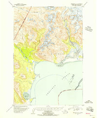 1951 Afognak C-61956 Print · USGSCoastal Alaska in the early fifties shows a landscape of transition where the wilderness of the Katmai National Monument meets the sea. Researchers can trace the locations of former settlements like Kaguyak and Swikshak along the Shelikof Strait.2 unique versions available
 - 1952 Map of Afognak, 1953 Print
 1952 Afognak1953 Print · USGSThe Afognak and Shelikof Strait region in the early fifties shows a remote landscape of maritime outposts and glacier-fed coasts. Researchers can locate coastal settlements like Port William, the Hatchery on Afognak, and the isolated village of Kaguyak.10 unique versions available
 - 2019 Map of Afognak C-6 SW, 2019 Print
 2019 Afognak C-6 SW2019 Print · USGSCoastal Kodiak Island and the eastern reaches of the Katmai wilderness are documented here in the early twenty-first century. Researchers can trace the wild shoreline from Cape Chiniak to the mouth of the Big River along Swikshak Bay.
End of results
Showing maps 1-3 of 3
Frequently asked questions
- What are the different types of historical maps available for Kaguyak?
- What is the oldest map of Kaguyak?
- Where can I purchase historical maps of Kaguyak for my home or office?
- Where can I download high-res historical maps of Kaguyak?
- Are there historical topographic maps available for Kaguyak?
- Is there historical aerial imagery available for Kaguyak?
- Where are historical maps of Kaguyak sourced from?