1900s (20th Century) Maps of Port Lions, Alaska
Explore 4 historic maps of Port Lions from the 1900s (20th Century). These maps offer a rare glimpse into what life looked like during the 1900s — showing old roads, neighborhoods, homes, and landmarks that have changed or disappeared over time.
Whether you're researching your family's past, planning a metal detecting trip, or studying how Port Lions's landscape evolved across the 1900s, these high-resolution maps are a powerful tool for exploring the history of this region.
- Focus on a specific era: All maps on this page are from the 1900s, giving you a focused view of this time period.
- See what’s changed: Compare century-old streets, trails, and buildings to today's modern landscape using overlays and satellite layers.
- Research with precision: Use these maps for genealogy, historical research, land use analysis, or educational projects.
- View, download, or print: Maps are fully viewable online in high resolution, and can be downloaded or printed for your own records.
Start exploring Port Lions's history through authentic maps from the 1900s. This is your window into the past.
Port Lions, AK maps
(4)- 1947 Map of Kodiak D-3, 1966 Print
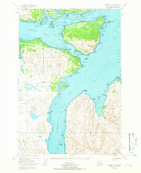 1947 Kodiak D-31966 Print · USGSThe Kodiak Archipelago's intricate coastlines and islands are captured here just after the mid-century. Trace the maritime geography of Port Lions and the mountainous stretches of the Kodiak National Wildlife Refuge near Whale Island.3 unique versions available
 - 1949 Map of Kodiak D-3, 1958 Print
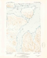
 1949 Kodiak D-31958 Print · USGSKodiak Island and its surrounding straits appear as a complex network of coastal points and deep bays in the late 1940s. Maritime researchers can trace old landmarks across Whale Island and Raspberry Island, including Settler Cove and Dolphin Point.
 - 1950 Map of Kodiak D-3
 1950 Kodiak D-31950 Print · USGSThe Kodiak archipelago in the mid-century reveals a wild coastal landscape of deep fjords and mountainous islands. Maritime historians and researchers can trace the intricate shoreline from Whale Island to the peaks of Sharatin Mountain and Barabara Cove.2 unique versions available
 - 1952 Map of Kodiak, 1953 Print
 1952 Kodiak1953 Print · USGSKodiak Island in the early fifties shows a landscape of strategic military bases and coastal fishing villages. Researchers can trace the layout of the Naval Reservation, the whaling station at Port Hobron, and remote settlements like Old Harbor.12 unique versions available
End of results
Showing maps 1-4 of 4
Frequently asked questions
- What are the different types of historical maps available for Port Lions?
- What is the oldest map of Port Lions?
- Where can I purchase historical maps of Port Lions for my home or office?
- Where can I download high-res historical maps of Port Lions?
- Are there historical topographic maps available for Port Lions?
- Is there historical aerial imagery available for Port Lions?
- Where are historical maps of Port Lions sourced from?