Old Maps of Port Lions, Alaska for Academic Research
Study the evolution of Port Lions with 7 high-resolution historic maps. Whether you're teaching, researching, or modeling changes in land use, these maps provide essential visual documentation of urban, environmental, and geographic change.
- Analyze long-term change: Track patterns in development, transportation, and natural features.
- Ideal for environmental or urban studies: Support academic projects with primary historical map data.
- Use in the classroom or lab: Educators and researchers rely on these maps to bring historical context to life.
These maps are a powerful tool for teaching, research, and visualizing how Port Lions has changed over the decades.
Port Lions, AK maps
(7)- 1947 Map of Kodiak D-3, 1966 Print
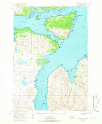 1947 Kodiak D-31966 Print · USGSThe Kodiak Archipelago's intricate coastlines and islands are captured here just after the mid-century. Trace the maritime geography of Port Lions and the mountainous stretches of the Kodiak National Wildlife Refuge near Whale Island.3 unique versions available
 - 1949 Map of Kodiak D-3, 1958 Print
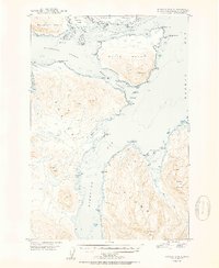
 1949 Kodiak D-31958 Print · USGSKodiak Island and its surrounding straits appear as a complex network of coastal points and deep bays in the late 1940s. Maritime researchers can trace old landmarks across Whale Island and Raspberry Island, including Settler Cove and Dolphin Point.
 - 1950 Map of Kodiak D-3
 1950 Kodiak D-31950 Print · USGSThe Kodiak archipelago in the mid-century reveals a wild coastal landscape of deep fjords and mountainous islands. Maritime historians and researchers can trace the intricate shoreline from Whale Island to the peaks of Sharatin Mountain and Barabara Cove.2 unique versions available
 - 1952 Map of Kodiak, 1953 Print
 1952 Kodiak1953 Print · USGSKodiak Island in the early fifties shows a landscape of strategic military bases and coastal fishing villages. Researchers can trace the layout of the Naval Reservation, the whaling station at Port Hobron, and remote settlements like Old Harbor.12 unique versions available
 - 2021 Map of Kodiak D-3 NW, 2021 Print
 2021 Kodiak D-3 NW2021 Print · USGSPort Lions on Kodiak Island stands as a vital coastal hub in the early twenty-first century. Researchers can trace the settlement's footprint near Kupreanof Strait and locate local landmarks like Mt Ellison and the Port Lions Airport.
 - 2021 Map of Kodiak D-3 NE, 2021 Print
 2021 Kodiak D-3 NE2021 Print · USGSCoastal waters near Kodiak Island are captured here in the early twenty-first century, showing the rugged littoral of Whale Island. Maritime researchers can trace the shorelines of Whale Passage and identify named landmarks like Shag Rocks and Opasni Point.
 - 2021 Map of Kodiak D-3 SW, 2021 Print
 2021 Kodiak D-3 SW2021 Print · USGSKodiak Island’s rugged coastline and local infrastructure are detailed here in the early twenty-first century. Researchers can trace the layout of Port Wakefield and its maritime access through Settler Cove and Harbor Road.
End of results
Showing maps 1-7 of 7
Frequently asked questions
- What are the different types of historical maps available for Port Lions?
- What is the oldest map of Port Lions?
- Where can I purchase historical maps of Port Lions for my home or office?
- Where can I download high-res historical maps of Port Lions?
- Are there historical topographic maps available for Port Lions?
- Is there historical aerial imagery available for Port Lions?
- Where are historical maps of Port Lions sourced from?