1900s (20th Century) Maps of Port William, Alaska
Explore 3 historic maps of Port William from the 1900s (20th Century). These maps offer a rare glimpse into what life looked like during the 1900s — showing old roads, neighborhoods, homes, and landmarks that have changed or disappeared over time.
Whether you're researching your family's past, planning a metal detecting trip, or studying how Port William's landscape evolved across the 1900s, these high-resolution maps are a powerful tool for exploring the history of this region.
- Focus on a specific era: All maps on this page are from the 1900s, giving you a focused view of this time period.
- See what’s changed: Compare century-old streets, trails, and buildings to today's modern landscape using overlays and satellite layers.
- Research with precision: Use these maps for genealogy, historical research, land use analysis, or educational projects.
- View, download, or print: Maps are fully viewable online in high resolution, and can be downloaded or printed for your own records.
Start exploring Port William's history through authentic maps from the 1900s. This is your window into the past.
Port William, AK maps
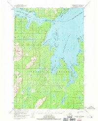
(3)- 1952 Map of Afognak, 1953 Print
 1952 Afognak1953 Print · USGSThe Afognak and Shelikof Strait region in the early fifties shows a remote landscape of maritime outposts and glacier-fed coasts. Researchers can locate coastal settlements like Port William, the Hatchery on Afognak, and the isolated village of Kaguyak.10 unique versions available
 - 1952 Map of Afognak B-2, 1971 Print
 1952 Afognak B-21971 Print · USGSAfognak and Shuyak Islands are captured in the early 1950s, showing a remote maritime landscape of seaplane bases and secluded bays. Genealogists and historians can locate isolated settlements at Port William and Port Lawrence or trace the coastline through Cape Current Narrows.3 unique versions available
 - 1954 Map of Afognak B-2, 1955 Print
 1954 Afognak B-21955 Print · USGSShuyak and Afognak Islands appear in the mid-1950s as a remote maritime frontier of inlets and coastal outposts. Researchers can trace early navigation points and small settlements like Port William, Port Lawrence, and the Lighthouse guarding the Shuyak Strait.
End of results
Showing maps 1-3 of 3
Frequently asked questions
- What are the different types of historical maps available for Port William?
- What is the oldest map of Port William?
- Where can I purchase historical maps of Port William for my home or office?
- Where can I download high-res historical maps of Port William?
- Are there historical topographic maps available for Port William?
- Is there historical aerial imagery available for Port William?
- Where are historical maps of Port William sourced from?