Old Maps of Port William, Alaska for Metal Detecting
Plan your next treasure hunt with 4 historic maps of Port William. Find old homesites, ghost towns, trails, and gathering spots that may be lost to time — perfect for identifying promising metal detecting locations.
- Locate forgotten sites: Uncover places like long-lost settlements, abandoned rail lines, or gathering spots.
- Plan better hunts: Use map overlays combined with LiDAR or satellite views to narrow in on historically rich areas.
- Made for detectorists: Thousands of hobbyists use these maps to discover relics, coins, and hidden history.
Use these historic maps to boost your research and find new opportunities beneath the surface of Port William.
Port William, AK maps
(4)- 1952 Map of Afognak, 1953 Print
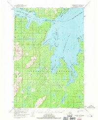
 1952 Afognak1953 Print · USGSThe Afognak and Shelikof Strait region in the early fifties shows a remote landscape of maritime outposts and glacier-fed coasts. Researchers can locate coastal settlements like Port William, the Hatchery on Afognak, and the isolated village of Kaguyak.10 unique versions available
 - 1952 Map of Afognak B-2, 1971 Print
 1952 Afognak B-21971 Print · USGSAfognak and Shuyak Islands are captured in the early 1950s, showing a remote maritime landscape of seaplane bases and secluded bays. Genealogists and historians can locate isolated settlements at Port William and Port Lawrence or trace the coastline through Cape Current Narrows.3 unique versions available
 - 1954 Map of Afognak B-2, 1955 Print
 1954 Afognak B-21955 Print · USGSShuyak and Afognak Islands appear in the mid-1950s as a remote maritime frontier of inlets and coastal outposts. Researchers can trace early navigation points and small settlements like Port William, Port Lawrence, and the Lighthouse guarding the Shuyak Strait.
 - 2021 Map of Afognak B-2 NW, 2021 Print
 2021 Afognak B-2 NW2021 Print · USGSKodiak Island at the start of the 2020s reveals a maritime landscape of deep bays and isolated outposts. Researchers can trace the rugged coastline of Shuyak Island and locate the settlement at Port William and the landmark at Lighthouse Point.
End of results
Showing maps 1-4 of 4
Frequently asked questions
- What are the different types of historical maps available for Port William?
- What is the oldest map of Port William?
- Where can I purchase historical maps of Port William for my home or office?
- Where can I download high-res historical maps of Port William?
- Are there historical topographic maps available for Port William?
- Is there historical aerial imagery available for Port William?
- Where are historical maps of Port William sourced from?