Old Maps of Womens Bay, Alaska for Genealogy
Trace your family roots with 4 historic maps of Womens Bay. These high-res maps reveal old neighborhoods, homesites, landmarks, and streets — helping you uncover where your ancestors lived and how the area evolved over time.
- Explore historic neighborhoods: Identify where your relatives may have lived in the 1800s or 1900s.
- Compare maps over time: Trace the changes in streets, buildings, and landmarks for multi-generational research.
- Perfect for genealogy & ancestry research: Used by family historians and researchers to map out lineage and migration.
These maps are an incredible resource for exploring your personal connection to Womens Bay's past.
Womens Bay, AK maps
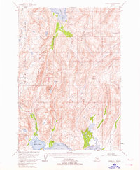
(4)- 1952 Map of Kodiak, 1953 Print
 1952 Kodiak1953 Print · USGSKodiak Island in the early fifties shows a landscape of strategic military bases and coastal fishing villages. Researchers can trace the layout of the Naval Reservation, the whaling station at Port Hobron, and remote settlements like Old Harbor.12 unique versions available
 - 1952 Map of Kodiak C-3, 1964 Print
 1952 Kodiak C-31964 Print · USGSKodiak Island’s interior and rugged southern coast are captured here in the early fifties, before modern development touched these remote drainages. Map collectors can trace the pristine flows of the Russian River and find landmarks like Crown Mountain and Saltery Cove.3 unique versions available
 - 1954 Map of Kodiak C-3, 1955 Print
 1954 Kodiak C-31955 Print · USGSKodiak Island in the early fifties remains a rugged wilderness of protected refuges and deep coastal inlets. Researchers can trace the interior boundaries of the Kodiak National Wildlife Refuge and locate remote features like Hidden Basin and Crown Mountain.
 - 2021 Map of Kodiak C-3 NE, 2021 Print
 2021 Kodiak C-3 NE2021 Print · USGSKodiak Island’s interior remains a remote wilderness defined by its steep elevations and mountain drainages in the early twenty-first century. Researchers can trace the paths of Russian Cr and Salonie Cr as they flow around the base of Center Mtn.
End of results
Showing maps 1-4 of 4
Top cities near Womens Bay
Frequently asked questions
- What are the different types of historical maps available for Womens Bay?
- What is the oldest map of Womens Bay?
- Where can I purchase historical maps of Womens Bay for my home or office?
- Where can I download high-res historical maps of Womens Bay?
- Are there historical topographic maps available for Womens Bay?
- Is there historical aerial imagery available for Womens Bay?
- Where are historical maps of Womens Bay sourced from?