Old Maps of Kaskanak, Alaska for Genealogy
Trace your family roots with 4 historic maps of Kaskanak. These high-res maps reveal old neighborhoods, homesites, landmarks, and streets — helping you uncover where your ancestors lived and how the area evolved over time.
- Explore historic neighborhoods: Identify where your relatives may have lived in the 1800s or 1900s.
- Compare maps over time: Trace the changes in streets, buildings, and landmarks for multi-generational research.
- Perfect for genealogy & ancestry research: Used by family historians and researchers to map out lineage and migration.
These maps are an incredible resource for exploring your personal connection to Kaskanak's past.
Kaskanak, AK maps
(4)- 1951 Map of Dillingham, 1952 Print
 1951 Dillingham1952 Print · USGSDillingham and the Bristol Bay river systems are captured here in the early fifties, showing a remote landscape linked by water and seasonal camps. Researchers can trace early settlements and post offices at New Stuyahok, Ekwok, and Kvichak.
 - 1954 Map of Dillingham, 1967 Print
 1954 Dillingham1967 Print · USGSBristol Bay's interior river systems are mapped here in the mid-1950s, showing a landscape defined by water and winter travel. Researchers can trace remote settlements like Koliganek and Levelock or find family landmarks along the Nushagak River and Lake Aleknagik.3 unique versions available
 - 1954 Map of Dillingham B-1, 1968 Print
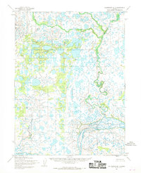 1954 Dillingham B-11968 Print · USGSThe Alaskan interior near the Kvichak River is captured here in the mid-1950s, showing a vast wilderness of water and tundra. Researchers can trace the winding paths of Kaskanak Creek and Bear Creek through a landscape dense with unnamed lakes.2 unique versions available
 - 2019 Map of Dillingham B-1 SE, 2019 Print
 2019 Dillingham B-1 SE2019 Print · USGSThe Kvichak River basin in the Lake and Peninsula Borough is captured here in the late twenty-teens, showcasing a vast network of subarctic wetlands. Modern researchers can trace the winding paths of Kaskanak Cr, Ole Cr, and the braided Kvichak River.
End of results
Showing maps 1-4 of 4
Frequently asked questions
- What are the different types of historical maps available for Kaskanak?
- What is the oldest map of Kaskanak?
- Where can I purchase historical maps of Kaskanak for my home or office?
- Where can I download high-res historical maps of Kaskanak?
- Are there historical topographic maps available for Kaskanak?
- Is there historical aerial imagery available for Kaskanak?
- Where are historical maps of Kaskanak sourced from?