1900s (20th Century) Maps of Nondalton, Alaska
Explore 8 historic maps of Nondalton from the 1900s (20th Century). These maps offer a rare glimpse into what life looked like during the 1900s — showing old roads, neighborhoods, homes, and landmarks that have changed or disappeared over time.
Whether you're researching your family's past, planning a metal detecting trip, or studying how Nondalton's landscape evolved across the 1900s, these high-resolution maps are a powerful tool for exploring the history of this region.
- Focus on a specific era: All maps on this page are from the 1900s, giving you a focused view of this time period.
- See what’s changed: Compare century-old streets, trails, and buildings to today's modern landscape using overlays and satellite layers.
- Research with precision: Use these maps for genealogy, historical research, land use analysis, or educational projects.
- View, download, or print: Maps are fully viewable online in high resolution, and can be downloaded or printed for your own records.
Start exploring Nondalton's history through authentic maps from the 1900s. This is your window into the past.
Nondalton, AK maps
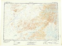
(8)- 1946 Map of Lake Clark, 1954 Print
 1946 Lake Clark1954 Print · USGSInterior Alaska during the mid-forties and early fifties reveals a remote landscape of glacial lakes and mountain peaks. You can trace early settlements at Nondalton, find the Old Village trail network, and locate the Tanalian Point Landing Field near the shores of Lake Clark.2 unique versions available
 - 1951 Map of Lake Clark
 1951 Lake Clark1951 Print · USGSThe Lake Clark region of the Alaskan interior was a remote frontier in the early 1950s, defined by high peaks and sprawling river systems. Researchers can trace historic travel routes like the Native Trail and locate isolated settlements at Old Village or Nondalton.2 unique versions available
 - 1952 Map of Iliamna, 1953 Print
 1952 Iliamna1953 Print · USGSAlaska's interior and coastline meet in this early 1950s survey of the Lake Iliamna region. Researchers can trace remote settlements and camps such as Fish Village, Old Iliamna (Aband), and Hammerly Camp at the edge of the Katmai National Monument.4 unique versions available
 - 1954 Map of Lake Clark A-5, 1965 Print
 1954 Lake Clark A-51965 Print · USGSThe Lake Clark region of Alaska was primarily a wilderness of interconnected water and peaks when these mid-century aerial surveys were conducted. Researchers can trace the shoreline from Keyes Point to the Chulitna River and locate the Base Line used by early surveyors.2 unique versions available
 - 1954 Map of Iliamna D-5, 1965 Print
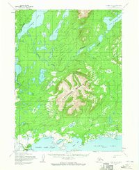 1954 Iliamna D-51965 Print · USGSIn the mid-1950s, the area surrounding Sixmile Lake and the northern shores of Iliamna Lake was a remote landscape of trails and river travel. Researchers can trace the early footprint of Nondalton, Fish Village, and the Native Trail near Roadhouse Mountain.2 unique versions available
 - 1954 Map of Iliamna D-6, 1968 Print
 1954 Iliamna D-61968 Print · USGSIliamna and the surrounding wilderness are captured in the mid-fifties, showing the vital connection between river travel and early aviation. Local researchers can trace the banks of the Newhalen River and locate the Iliamna Airport and Pike Lake.
 - 1957 Map of Iliamna, 1965 Print
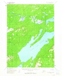
 1957 Iliamna1965 Print · USGSSouthwestern Alaska in the late fifties centers on the massive waters of Iliamna Lake and its surrounding villages. Trace family roots and old routes at Old Roadhouse, Newhalen, and the Kamishak (Site) near the edge of Katmai National Monument.7 unique versions available
 - 1958 Map of Lake Clark, 1967 Print
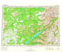 1958 Lake Clark1967 Print · USGSLake Clark and the surrounding wilderness are captured during the 1950s as a remote frontier of rivers and volcanic peaks. Researchers can locate early outposts like Port Alsworth and trace the paths of the Summit Trail or the waters of Kontrashibuna Lake.4 unique versions available
End of results
Showing maps 1-8 of 8
Top cities near Nondalton
Top neighborhoods of Nondalton
Frequently asked questions
- What are the different types of historical maps available for Nondalton?
- What is the oldest map of Nondalton?
- Where can I purchase historical maps of Nondalton for my home or office?
- Where can I download high-res historical maps of Nondalton?
- Are there historical topographic maps available for Nondalton?
- Is there historical aerial imagery available for Nondalton?
- Where are historical maps of Nondalton sourced from?