
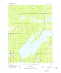
1954 Map of Lake Clark A-5
USGS Topo · Published 1965About this map
Lake Clark dominates this mid-century landscape, serving as the central geographic feature for a territory defined by its water-linked topography. The survey, conducted through aerial photography by the Army Map Service, details the intricate shoreline where Portage Bay and Turner Bay provide protected coves against the high ground of Keyes Point. To the north, the Chulitna River winds through lower-lying marshlands before emptying into Chulitna Bay, creating a complex network of seasonal drainage and wetlands.
Find a feature on this map
12 named features on this map. Tap any name to fly to it.
Don’t see what you’re looking for? This feature index may not catch every label — zoom into the map to look around manually.
Map Details
Editions of this 1954 Lake Clark A-5 Map
2 editions found
Other maps of this area

1946 · Lake Clark
USGS Topo · 1:250,000

1951 · Lake Clark
USGS Topo · 1:250,000

1952 · Iliamna
USGS Topo · 1:250,000

1954 · Lake Clark A-6
USGS Topo · 1:63,360

1954 · Lake Clark B-5
USGS Topo · 1:63,360

1954 · Iliamna D-4
USGS Topo · 1:63,360

1954 · Lake Clark A-4
USGS Topo · 1:63,360

1954 · Iliamna D-5
USGS Topo · 1:63,360

1954 · Lake Clark B-4
USGS Topo · 1:63,360

1954 · Lake Clark B-6
USGS Topo · 1:63,360