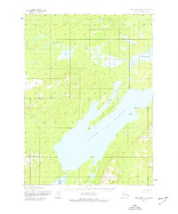
1954 Map of Lake Clark A-5
USGS Topo · Published 1977About this map
Lake Clark dominates this mid-century sub-arctic landscape, its waters reaching an elevation of 254 feet. The map documents a transition point in Southwest Alaska where the Chulitna River feeds into Chulitna Bay, creating a complex network of wetlands and smaller basins like Turner Bay and Portage Bay. To the south, the topography rises toward Hoknede Mountain and descends into Sixmile Lake.
Find a feature on this map
13 named features on this map. Tap any name to fly to it.
Don’t see what you’re looking for? This feature index may not catch every label — zoom into the map to look around manually.
Map Details
Editions of this 1954 Lake Clark A-5 Map
2 editions found
Other maps of this area

1946 · Lake Clark
USGS Topo · 1:250,000

1951 · Lake Clark
USGS Topo · 1:250,000

1952 · Iliamna
USGS Topo · 1:250,000

1954 · Lake Clark A-6
USGS Topo · 1:63,360

1954 · Lake Clark B-5
USGS Topo · 1:63,360

1954 · Iliamna D-4
USGS Topo · 1:63,360

1954 · Lake Clark A-4
USGS Topo · 1:63,360

1954 · Lake Clark A-5
USGS Topo · 1:63,360

1954 · Iliamna D-5
USGS Topo · 1:63,360

1954 · Lake Clark B-4
USGS Topo · 1:63,360