
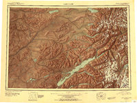
1951 Map of Lake Clark
USGS Topo · Published 1951About this map
Lake Clark dominates this 1951 study of the interior Alaskan wilderness, where the jagged peaks of the Alaska Range and Chigmit Mountains meet a complex network of glacial rivers and alpine lakes. Settlement is sparse, anchored by the Old Village near Telaquana Lake and Nondalton to the southwest, connected by a long Native Trail and a Portage Trail that trace historical movement through the valleys. The landscape is defined by its extreme elevation changes, from the shores of Portage Bay to the towering Iliamna Volcano. Several cabins and a remote Landing Field near Tanalian Point indicate the early 1950s infrastructure used for access. Significant waterways like the Mulchatna River and Koksetna River drain the high country, while isolated features such as Kijik Mtn and the Bonanza Hills stand as prominent landmarks for aerial and ground navigation during this era of reconnaissance mapping.
Find a feature on this map
57 named features on this map. Tap any name to fly to it.
Don’t see what you’re looking for? This feature index may not catch every label — zoom into the map to look around manually.
Map Details
Editions of this 1951 Lake Clark Map
2 editions found
Other maps of this area

1944 · Kenai
USGS Topo · 1:250,000

1946 · Lake Clark
USGS Topo · 1:250,000

1949 · Tyonek
USGS Topo · 1:250,000

1950 · Kenai
USGS Topo · 1:250,000

1950 · Sleetmute
USGS Topo · 1:250,000

1950 · Taylor Mountains
USGS Topo · 1:250,000

1951 · Taylor Mountains
USGS Topo · 1:250,000

1951 · Tyonek
USGS Topo · 1:250,000

1951 · Lime Hills
USGS Topo · 1:250,000

1951 · Dillingham
USGS Topo · 1:250,000