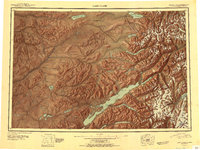
1951 Map of Lake Clark
USGS Topo · Published 1951About this map
Lake Clark dominates this mid-century reconnaissance of the Alaska interior, serving as the central drainage for an intricate network of rivers including the Tlikakila River and Chulitna River. The map illustrates a landscape defined by its waterways and elevation, with the massive Iliamna Volcano rising in the southeast and the Bonanza Hills to the north. Settlement is sparse, represented by small outposts and indigenous sites such as Old Village near Lake Telaquana and the settlement of Nondalton situated between Sixmile Lake and the Chulitna River.
Find a feature on this map
55 named features on this map. Tap any name to fly to it.
Don’t see what you’re looking for? This feature index may not catch every label — zoom into the map to look around manually.
Map Details
Editions of this 1951 Lake Clark Map
2 editions found
Other maps of this area

1944 · Kenai
USGS Topo · 1:250,000

1946 · Lake Clark
USGS Topo · 1:250,000

1949 · Tyonek
USGS Topo · 1:250,000

1950 · Kenai
USGS Topo · 1:250,000

1950 · Sleetmute
USGS Topo · 1:250,000

1950 · Taylor Mountains
USGS Topo · 1:250,000

1951 · Lake Clark
USGS Topo · 1:250,000

1951 · Taylor Mountains
USGS Topo · 1:250,000

1951 · Tyonek
USGS Topo · 1:250,000

1951 · Lime Hills
USGS Topo · 1:250,000