
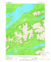
1954 Map of Lake Clark A-4
USGS Topo · Published 1965About this map
Port Alsworth serves as the primary human anchor on the southeastern shore of Lake Clark, positioned strategically near the mouth of the Tanalian River. This mid-century survey reflects a wilderness landscape defined by high alpine lakes and glacial drainages, including the dramatic Kontrashibuna Lake and the connected waters of Upper Tazimina Lake and Lower Tazimina Lake. The importance of bush aviation in this roadless region is highlighted by the Tanalian Point Landing Field, which provides vital access to the settlement on Tanalian Point. Steep elevation changes are dominated by the massive profile of Tanalian Mountain, while the jagged coastline is punctuated by features like Hardenburg Bay and Cape Shishkin. The hydrography is intricately detailed, from the broad Tazimina River to smaller drainages like Takoka Creek and Tommy Creek, illustrating the natural water systems of the Alaska Peninsula.
Find a feature on this map
16 named features on this map. Tap any name to fly to it.
Don’t see what you’re looking for? This feature index may not catch every label — zoom into the map to look around manually.
Map Details
Editions of this 1954 Lake Clark A-4 Map
2 editions found
Other maps of this area

1946 · Lake Clark
USGS Topo · 1:250,000

1951 · Lake Clark
USGS Topo · 1:250,000

1952 · Iliamna
USGS Topo · 1:250,000

1954 · Lake Clark A-3
USGS Topo · 1:63,360

1954 · Lake Clark B-5
USGS Topo · 1:63,360

1954 · Iliamna D-3
USGS Topo · 1:63,360

1954 · Lake Clark B-3
USGS Topo · 1:63,360

1954 · Iliamna D-4
USGS Topo · 1:63,360

1954 · Lake Clark A-5
USGS Topo · 1:63,360

1954 · Iliamna D-5
USGS Topo · 1:63,360