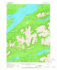
1954 Map of Lake Clark A-4
USGS Topo · Published 1968About this map
Port Alsworth sits as the primary settlement on this mid-century survey, positioned strategically at Hardenburg Bay along the eastern shore of Lake Clark. The map documents a nascent transportation infrastructure, specifically a Landing Field near Tanalian Point, which served as a vital link for this remote community before the expansion of modern road networks. The geography is defined by a series of significant inland water bodies and river systems, including the Tanalian River and the connected basins of Upper Tazimina Lake and Lower Tazimina Lake. Rising above the settlement, Tanalian Mountain dominates the local topography, situated between the main lake and Kontrashibuna Lake. This map captures the region when land lines remained largely unsurveyed and unmarked, reflecting the early administrative state of what would later become part of the Lake and Peninsula Borough.
Find a feature on this map
17 named features on this map. Tap any name to fly to it.
Don’t see what you’re looking for? This feature index may not catch every label — zoom into the map to look around manually.
Map Details
Editions of this 1954 Lake Clark A-4 Map
2 editions found
Other maps of this area

1946 · Lake Clark
USGS Topo · 1:250,000

1951 · Lake Clark
USGS Topo · 1:250,000

1952 · Iliamna
USGS Topo · 1:250,000

1954 · Lake Clark A-3
USGS Topo · 1:63,360

1954 · Lake Clark B-5
USGS Topo · 1:63,360

1954 · Iliamna D-3
USGS Topo · 1:63,360

1954 · Lake Clark B-3
USGS Topo · 1:63,360

1954 · Iliamna D-4
USGS Topo · 1:63,360

1954 · Lake Clark A-4
USGS Topo · 1:63,360

1954 · Lake Clark A-5
USGS Topo · 1:63,360