
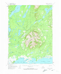
1954 Map of Iliamna D-5
USGS Topo · Published 1965About this map
Nondalton sits along the western shore of Sixmile Lake, a focal point for settlement and transport in this 1950s interior Alaskan landscape. To the south, the massive presence of Roadhouse Mountain divides the drainage of the Tazimina River and the lower reaches of the Newhalen River. The map documents a sparse but vital network of early infrastructure, including a Native Trail winding through the northern terrain and several established points along the northern edge of Iliamna Lake. Local fishing and transport sites like Fish Village, Seversens, and a named Roadhouse mark the human footprint in a region defined by complex waterways like Whistlewing Bay and Eagle Bay. This survey captures the region's character as a crossroads of river travel and terrestrial trails before modern development altered the remote character of these Lake and Peninsula watersheds.
Find a feature on this map
25 named features on this map. Tap any name to fly to it.
Don’t see what you’re looking for? This feature index may not catch every label — zoom into the map to look around manually.
Map Details
Editions of this 1954 Iliamna D-5 Map
2 editions found
Other maps of this area

1946 · Lake Clark
USGS Topo · 1:250,000

1951 · Lake Clark
USGS Topo · 1:250,000

1952 · Iliamna
USGS Topo · 1:250,000

1954 · Iliamna C-6
USGS Topo · 1:63,360

1954 · Lake Clark A-6
USGS Topo · 1:63,360

1954 · Iliamna C-5
USGS Topo · 1:63,360

1954 · Iliamna D-4
USGS Topo · 1:63,360

1954 · Lake Clark A-4
USGS Topo · 1:63,360

1954 · Iliamna C-4
USGS Topo · 1:63,360

1954 · Lake Clark A-5
USGS Topo · 1:63,360