
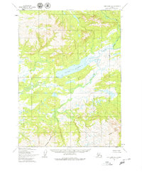
1954 Map of Lake Clark A-6
USGS Topo · Published 1964About this map
Chulitna River and Koksetna River define the hydraulic character of this mid-century Alaskan landscape, where drainage patterns are meticulously recorded before modern development. This mid-century survey, based on aerial photography from 1953 to 1957, reveals a wilderness largely devoid of established roads or trails. The terrain is anchored by significant elevations such as Groundhog Mountain in the south and Hoknede Mountain in the southeast. A central geographic feature is the elongated Long Lake, which sits just north of the Seward Base Line, a critical surveying marker for the region. The map captures a moment when the Bureau of Land Management and the Army Map Service were still formalizing the topographic record of the interior, documenting isolated water bodies like Joe Nort Lake amidst the high-elevation contours of the Alaska Range.
Find a feature on this map
6 named features on this map. Tap any name to fly to it.
Don’t see what you’re looking for? This feature index may not catch every label — zoom into the map to look around manually.
Map Details
Editions of this 1954 Lake Clark A-6 Map
2 editions found
Other maps of this area

1946 · Lake Clark
USGS Topo · 1:250,000

1951 · Lake Clark
USGS Topo · 1:250,000

1952 · Iliamna
USGS Topo · 1:250,000

1954 · Lake Clark A-7
USGS Topo · 1:63,360

1954 · Lake Clark B-5
USGS Topo · 1:63,360

1954 · Lake Clark A-5
USGS Topo · 1:63,360

1954 · Iliamna D-5
USGS Topo · 1:63,360

1954 · Lake Clark B-6
USGS Topo · 1:63,360

1954 · Iliamna D-7
USGS Topo · 1:63,360
1954 · Lake Clark B-7
USGS Topo · 1:63,360