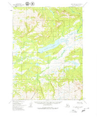
1954 Map of Lake Clark A-6
USGS Topo · Published 1979About this map
Long Lake dominates the center of this remote Alaskan landscape, where the Seward Base Line divides the survey into northern and southern ranges. The drainage pattern is defined by the Chulitna River and the Koksetna River, which wind through the lowlands before meeting the higher elevations of Groundhog Mountain and Hoknede Mountain in the south. Unlike more settled regions, this area shows no roads or trails, illustrating the untouched character of the Lake Clark region in the mid-1950s. The map serves as a primary record of the hydrography of the territory, including smaller water bodies like Joe Nort Lake and tributaries such as Groundhog Creek and Rock Creek.
Find a feature on this map
9 named features on this map. Tap any name to fly to it.
Don’t see what you’re looking for? This feature index may not catch every label — zoom into the map to look around manually.
Map Details
Editions of this 1954 Lake Clark A-6 Map
2 editions found
Other maps of this area

1946 · Lake Clark
USGS Topo · 1:250,000

1951 · Lake Clark
USGS Topo · 1:250,000

1952 · Iliamna
USGS Topo · 1:250,000

1954 · Lake Clark A-7
USGS Topo · 1:63,360

1954 · Lake Clark A-6
USGS Topo · 1:63,360

1954 · Lake Clark B-5
USGS Topo · 1:63,360

1954 · Lake Clark A-5
USGS Topo · 1:63,360

1954 · Iliamna D-5
USGS Topo · 1:63,360

1954 · Lake Clark B-6
USGS Topo · 1:63,360

1954 · Iliamna D-7
USGS Topo · 1:63,360