
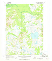
1954 Map of Lake Clark B-6
USGS Topo · Published 1968About this map
Koksetna River winds through this Alaskan interior landscape, joined by its tributaries in a drainage pattern that reveals the complex glacial topography of the Lake Clark region. The map captures the area as it was surveyed in the 1950s, showing a wilderness dominated by river networks and high elevation markers like Mesa Mountain. The Chilitna River flows through the northern reaches of the quadrangle, while Black Creek defines the lower drainage basins. This survey is particularly notable for its record of land lines representing unsurveyed and unmarked locations predetermined by the Bureau of Land Management, reflecting the early administrative efforts to organize this roadless territory.
Find a feature on this map
4 named features on this map. Tap any name to fly to it.
Don’t see what you’re looking for? This feature index may not catch every label — zoom into the map to look around manually.
Map Details
Editions of this 1954 Lake Clark B-6 Map
This is the sole edition of this map. No revisions or reprints were ever made.
Other maps of this area

1946 · Lake Clark
USGS Topo · 1:250,000

1951 · Lake Clark
USGS Topo · 1:250,000

1954 · Lake Clark C-7
USGS Topo · 1:63,360

1954 · Lake Clark A-7
USGS Topo · 1:63,360

1954 · Lake Clark C-6
USGS Topo · 1:63,360

1954 · Lake Clark A-6
USGS Topo · 1:63,360

1954 · Lake Clark B-5
USGS Topo · 1:63,360

1954 · Lake Clark A-5
USGS Topo · 1:63,360

1954 · Lake Clark C-5
USGS Topo · 1:63,360
1954 · Lake Clark B-7
USGS Topo · 1:63,360