
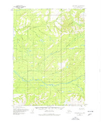
1954 Map of Lake Clark C-5
USGS Topo · Published 1965About this map
The Bonanza Hills dominate the northern landscape of this interior Alaskan region, as recorded through aerial photogrammetry in the early 1950s. The terrain is defined by a dense network of high-altitude drainages, most notably the Chilikadrotna River which cuts westward across the lower third of the quadrangle. This glacial and fluvial environment shows a complex pattern of seasonal water bodies and small tarns scattered among the ridges. Tributaries such as Bonanza Creek and Ptarmigan Creek descend from the heights to feed the larger river systems. In the southeast, the Little Mulchatna River joins the drainage network, illustrating the watershed's role in the broader Bristol Bay drainage basin. The map represents an era of systematic mapping where land lines were predetermined by the Bureau of Land Management but remained unsurveyed on the ground, reflecting the remote nature of the territory at mid-century.
Find a feature on this map
5 named features on this map. Tap any name to fly to it.
Don’t see what you’re looking for? This feature index may not catch every label — zoom into the map to look around manually.
Map Details
Editions of this 1954 Lake Clark C-5 Map
2 editions found
Other maps of this area

1946 · Lake Clark
USGS Topo · 1:250,000

1951 · Lake Clark
USGS Topo · 1:250,000

1954 · Lake Clark C-6
USGS Topo · 1:63,360

1954 · Lake Clark C-4
USGS Topo · 1:63,360

1954 · Lake Clark B-5
USGS Topo · 1:63,360

1954 · Lake Clark D-5
USGS Topo · 1:63,360

1954 · Lake Clark B-4
USGS Topo · 1:63,360

1954 · Lake Clark D-4
USGS Topo · 1:63,360

1954 · Lake Clark B-6
USGS Topo · 1:63,360
1954 · Lake Clark D-6
USGS Topo · 1:63,360