1954 Map of Lake Clark D-5
USGS Topo · Published 1965About this map
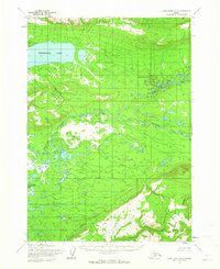
Whitefish Lake sits at the northern edge of this Alaskan interior landscape, acting as a significant water body in a region defined by complex drainage patterns. The Mulchatna River winds across the center of the sheet, highlighting the hydrological importance of this area within the Seward Meridian. To the south, the terrain rises into the Bonanza Hills, where Bonanza Creek originates and flows southward. The presence of Half Cabin Lake in the southwest corner suggests early human activity or seasonal outposts in an otherwise unpopulated wilderness. These unsurveyed land lines, predetermined by the Bureau of Land Management, show the early administrative efforts to organize this remote territory following aerial photography missions in the mid-1950s.
Find a feature on this map
5 named features on this map. Tap any name to fly to it.
Don’t see what you’re looking for? This feature index may not catch every label — zoom into the map to look around manually.
Map Details
Editions of this 1954 Lake Clark D-5 Map
2 editions found
Historical Maps of Unorganized Borough Through Time
732 maps found

1946 Lake Clark
Lake and Peninsula Borough, AK

1948 Mt Katmai
Lake and Peninsula Borough, AK

1951 Bristol Bay
Lake and Peninsula Borough, AK

1951 Dillingham A-1
Lake and Peninsula Borough, AK

1951 Iliamna A-6
Lake and Peninsula Borough, AK

1951 Iliamna A-7
Lake and Peninsula Borough, AK

1951 Iliamna A-8
Lake and Peninsula Borough, AK

1951 Iliamna B-5
Lake and Peninsula Borough, AK

1951 Iliamna B-6
Lake and Peninsula Borough, AK

1951 Iliamna B-7
Lake and Peninsula Borough, AK

1951 Karluk D-5
Lake and Peninsula Borough, AK

1951 Karluk D-6
Lake and Peninsula Borough, AK

1951 Lake Clark
Lake and Peninsula Borough, AK

1951 Mount Katmai A-6
Lake and Peninsula Borough, AK

1951 Mount Katmai B-3
Lake and Peninsula Borough, AK

1951 Mount Katmai B-5
Lake and Peninsula Borough, AK

1951 Mount Katmai B-6
Lake and Peninsula Borough, AK

1951 Mount Katmai C-2
Lake and Peninsula Borough, AK

1951 Mount Katmai C-3
Lake and Peninsula Borough, AK

1951 Mount Katmai C-4
Lake and Peninsula Borough, AK

1951 Mount Katmai C-5
Lake and Peninsula Borough, AK

1951 Mount Katmai C-6
Lake and Peninsula Borough, AK

1951 Mount Katmai D-3
Lake and Peninsula Borough, AK

1951 Mount Katmai D-4
Lake and Peninsula Borough, AK

1951 Mount Katmai D-6
Lake and Peninsula Borough, AK

1951 Mt. Katmai A-5
Lake and Peninsula Borough, AK

1951 Mt. Katmai B-4
Lake and Peninsula Borough, AK

1951 Mt. Katmai B-5
Lake and Peninsula Borough, AK

1951 Mt Katmai
Lake and Peninsula Borough, AK

1951 Naknek A-1
Lake and Peninsula Borough, AK

1951 Naknek A-2
Lake and Peninsula Borough, AK

1951 Naknek A-3
Lake and Peninsula Borough, AK

1951 Naknek A-4
Lake and Peninsula Borough, AK

1951 Naknek A-5
Lake and Peninsula Borough, AK

1951 Naknek B-1
Lake and Peninsula Borough, AK

1951 Naknek C-1
Lake and Peninsula Borough, AK

1951 Naknek D-1
Lake and Peninsula Borough, AK

1951 Stepovak Bay
Lake and Peninsula Borough, AK

1951 Sutwik Island
Lake and Peninsula Borough, AK

1951 Ugashik A-2
Lake and Peninsula Borough, AK

1951 Ugashik B-3
Lake and Peninsula Borough, AK

1951 Ugashik C-1
Lake and Peninsula Borough, AK

1951 Ugashik C-2
Lake and Peninsula Borough, AK

1951 Ugashik C-3
Lake and Peninsula Borough, AK

1951 Ugashik C-4
Lake and Peninsula Borough, AK

1951 Ugashik C-5
Lake and Peninsula Borough, AK

1951 Ugashik C-6
Lake and Peninsula Borough, AK

1951 Ugashik D-1
Lake and Peninsula Borough, AK

1951 Ugashik D-2
Lake and Peninsula Borough, AK

1951 Ugashik D-3
Lake and Peninsula Borough, AK

1951 Ugashik D-4
Lake and Peninsula Borough, AK

1951 Ugashik D-5 and D-6
Lake and Peninsula Borough, AK

1952 Dillingham A-2
Lake and Peninsula Borough, AK

1952 Dillingham A-3
Lake and Peninsula Borough, AK

1952 Iliamna A-8
Lake and Peninsula Borough, AK

1952 Naknek B-2
Lake and Peninsula Borough, AK

1952 Naknek B-3
Lake and Peninsula Borough, AK

1952 Naknek B-4
Lake and Peninsula Borough, AK

1952 Naknek B-5
Lake and Peninsula Borough, AK

1952 Naknek C-6
Lake and Peninsula Borough, AK

1953 Mount Katmai B-5
Lake and Peninsula Borough, AK

1953 Mount Katmai C-2
Lake and Peninsula Borough, AK

1953 Mount Katmai C-5
Lake and Peninsula Borough, AK

1953 Mt. Katmai B-6
Lake and Peninsula Borough, AK

1954 Dillingham B-1
Lake and Peninsula Borough, AK

1954 Dillingham B-2
Lake and Peninsula Borough, AK

1954 Iliamna B-5
Lake and Peninsula Borough, AK

1954 Iliamna B-6
Lake and Peninsula Borough, AK

1954 Iliamna B-8
Lake and Peninsula Borough, AK

1954 Iliamna C-3
Lake and Peninsula Borough, AK

1954 Iliamna C-4
Lake and Peninsula Borough, AK

1954 Iliamna C-5
Lake and Peninsula Borough, AK

1954 Iliamna C-6
Lake and Peninsula Borough, AK

1954 Iliamna C-7
Lake and Peninsula Borough, AK

1954 Iliamna C-8
Lake and Peninsula Borough, AK

1954 Iliamna D-3
Lake and Peninsula Borough, AK

1954 Iliamna D-4
Lake and Peninsula Borough, AK

1954 Iliamna D-5
Lake and Peninsula Borough, AK

1954 Iliamna D-6
Lake and Peninsula Borough, AK

1954 Iliamna D-7
Lake and Peninsula Borough, AK

1954 Iliamna D-8
Lake and Peninsula Borough, AK

1954 Lake Clark A-3
Lake and Peninsula Borough, AK

1954 Lake Clark A-4
Lake and Peninsula Borough, AK

1954 Lake Clark A-5
Lake and Peninsula Borough, AK

1954 Lake Clark A-6
Lake and Peninsula Borough, AK

1954 Lake Clark A-7
Lake and Peninsula Borough, AK

1954 Lake Clark A-8
Lake and Peninsula Borough, AK

1954 Lake Clark B-3
Lake and Peninsula Borough, AK

1954 Lake Clark B-4
Lake and Peninsula Borough, AK

1954 Lake Clark B-5
Lake and Peninsula Borough, AK

1954 Lake Clark B-6
Lake and Peninsula Borough, AK

1954 Lake Clark B-7
Lake and Peninsula Borough, AK

1954 Lake Clark B-8
Lake and Peninsula Borough, AK

1954 Lake Clark C-3
Lake and Peninsula Borough, AK

1954 Lake Clark C-4
Lake and Peninsula Borough, AK

1954 Lake Clark C-5
Lake and Peninsula Borough, AK

1954 Lake Clark C-6
Lake and Peninsula Borough, AK

1954 Lake Clark C-7
Lake and Peninsula Borough, AK

1954 Lake Clark C-8
Lake and Peninsula Borough, AK

1954 Lake Clark D-3
Lake and Peninsula Borough, AK

1954 Lake Clark D-4
Lake and Peninsula Borough, AK

1954 Lake Clark D-5
Lake and Peninsula Borough, AK

1954 Lake Clark D-6
Lake and Peninsula Borough, AK

1954 Lake Clark D-7
Lake and Peninsula Borough, AK

1954 Lake Clark D-8
Lake and Peninsula Borough, AK

1954 Sutwik Island D-3
Lake and Peninsula Borough, AK

1954 Ugashik A-3
Lake and Peninsula Borough, AK

1954 Ugashik B-4
Lake and Peninsula Borough, AK

1954 Ugashik B-5
Lake and Peninsula Borough, AK

1958 Lake Clark B-2
Lake and Peninsula Borough, AK

1958 Lake Clark C-2
Lake and Peninsula Borough, AK

1958 Lake Clark D-2
Lake and Peninsula Borough, AK

1958 Lake Clark
Lake and Peninsula Borough, AK

1963 Bristol Bay A-1
Lake and Peninsula Borough, AK

1963 Bristol Bay A-2
Lake and Peninsula Borough, AK

1963 Bristol Bay B-1
Lake and Peninsula Borough, AK

1963 Bristol Bay
Lake and Peninsula Borough, AK

1963 Chignik A-1
Lake and Peninsula Borough, AK

1963 Chignik A-2
Lake and Peninsula Borough, AK

1963 Chignik A-3
Lake and Peninsula Borough, AK

1963 Chignik A-4
Lake and Peninsula Borough, AK

1963 Chignik A-5
Lake and Peninsula Borough, AK

1963 Chignik B-1
Lake and Peninsula Borough, AK

1963 Chignik B-2
Lake and Peninsula Borough, AK

1963 Chignik B-3
Lake and Peninsula Borough, AK

1963 Chignik B-4
Lake and Peninsula Borough, AK

1963 Chignik B-5
Lake and Peninsula Borough, AK

1963 Chignik B-6
Lake and Peninsula Borough, AK

1963 Chignik C-1
Lake and Peninsula Borough, AK

1963 Chignik C-2
Lake and Peninsula Borough, AK

1963 Chignik C-3
Lake and Peninsula Borough, AK

1963 Chignik C-4
Lake and Peninsula Borough, AK

1963 Chignik D-1
Lake and Peninsula Borough, AK

1963 Chignik D-2
Lake and Peninsula Borough, AK

1963 Chignik D-3
Lake and Peninsula Borough, AK

1963 Stepovak Bay D-2
Lake and Peninsula Borough, AK

1963 Stepovak Bay D-3
Lake and Peninsula Borough, AK

1963 Stepovak Bay D-4
Lake and Peninsula Borough, AK

1963 Stepovak Bay D-5
Lake and Peninsula Borough, AK

1963 Stepovak Bay
Lake and Peninsula Borough, AK

1963 Sutwik Island B-6
Lake and Peninsula Borough, AK

1963 Sutwik Island C-4
Lake and Peninsula Borough, AK

1963 Sutwik Island C-5
Lake and Peninsula Borough, AK

1963 Sutwik Island C-6
Lake and Peninsula Borough, AK

1963 Sutwik Island D-4
Lake and Peninsula Borough, AK

1963 Sutwik Island D-5
Lake and Peninsula Borough, AK

1963 Sutwik Island D-6
Lake and Peninsula Borough, AK

1963 Sutwik Island
Lake and Peninsula Borough, AK

1963 Ugashik A-4
Lake and Peninsula Borough, AK

1963 Ugashik A-5
Lake and Peninsula Borough, AK

1963 Ugashik A-6
Lake and Peninsula Borough, AK

1963 Ugashik B-6
Lake and Peninsula Borough, AK

1964 Mt. Katmai
Lake and Peninsula Borough, AK

1967 Bristol Bay
Lake and Peninsula Borough, AK

1969 Stepovak Bay
Lake and Peninsula Borough, AK

1989 Sutwik Island D-2
Lake and Peninsula Borough, AK

2018 Iliamna A-5 NW
Lake and Peninsula Borough, AK

2018 Iliamna A-5 SW
Lake and Peninsula Borough, AK

2018 Iliamna B-4 NE
Lake and Peninsula Borough, AK

2018 Iliamna B-4 NW
Lake and Peninsula Borough, AK

2018 Iliamna B-5 NE
Lake and Peninsula Borough, AK

2018 Iliamna B-5 NW
Lake and Peninsula Borough, AK

2018 Iliamna B-5 SE
Lake and Peninsula Borough, AK

2018 Iliamna B-5 SW
Lake and Peninsula Borough, AK

2018 Iliamna C-3 NW
Lake and Peninsula Borough, AK

2018 Iliamna C-4 NE
Lake and Peninsula Borough, AK

2018 Iliamna C-4 NW
Lake and Peninsula Borough, AK

2018 Iliamna C-4 SE
Lake and Peninsula Borough, AK

2018 Iliamna C-4 SW
Lake and Peninsula Borough, AK

2018 Iliamna C-5 NE
Lake and Peninsula Borough, AK

2018 Iliamna C-5 NW
Lake and Peninsula Borough, AK

2018 Iliamna C-5 SE
Lake and Peninsula Borough, AK

2018 Iliamna C-5 SW
Lake and Peninsula Borough, AK

2018 Iliamna D-3 NE
Lake and Peninsula Borough, AK

2018 Iliamna D-3 SE
Lake and Peninsula Borough, AK

2018 Iliamna D-3 SW
Lake and Peninsula Borough, AK

2018 Iliamna D-4 NE
Lake and Peninsula Borough, AK

2018 Iliamna D-4 NW
Lake and Peninsula Borough, AK

2018 Iliamna D-4 SE
Lake and Peninsula Borough, AK

2018 Iliamna D-4 SW
Lake and Peninsula Borough, AK

2018 Iliamna D-5 NE
Lake and Peninsula Borough, AK

2018 Iliamna D-5 NW
Lake and Peninsula Borough, AK

2018 Iliamna D-5 SE
Lake and Peninsula Borough, AK

2018 Iliamna D-5 SW
Lake and Peninsula Borough, AK

2018 Lake Clark A-2 NW
Lake and Peninsula Borough, AK

2018 Lake Clark A-2 SW
Lake and Peninsula Borough, AK

2018 Lake Clark A-3 NE
Lake and Peninsula Borough, AK

2018 Lake Clark A-3 SE
Lake and Peninsula Borough, AK

2018 Lake Clark A-4 NE
Lake and Peninsula Borough, AK

2018 Lake Clark A-4 NW
Lake and Peninsula Borough, AK

2018 Lake Clark A-4 SE
Lake and Peninsula Borough, AK

2018 Lake Clark A-4 SW
Lake and Peninsula Borough, AK

2018 Lake Clark A-5 NE
Lake and Peninsula Borough, AK

2018 Lake Clark A-5 NW
Lake and Peninsula Borough, AK

2018 Lake Clark A-5 SE
Lake and Peninsula Borough, AK

2018 Lake Clark A-5 SW
Lake and Peninsula Borough, AK

2018 Lake Clark B-2 NW
Lake and Peninsula Borough, AK

2018 Lake Clark B-2 SW
Lake and Peninsula Borough, AK

2018 Lake Clark B-3 NE
Lake and Peninsula Borough, AK

2018 Lake Clark B-3 SE
Lake and Peninsula Borough, AK

2018 Lake Clark B-4 NE
Lake and Peninsula Borough, AK

2018 Lake Clark B-4 NW
Lake and Peninsula Borough, AK

2018 Lake Clark B-4 SE
Lake and Peninsula Borough, AK

2018 Lake Clark B-4 SW
Lake and Peninsula Borough, AK

2018 Lake Clark B-5 NE
Lake and Peninsula Borough, AK

2018 Lake Clark B-5 NW
Lake and Peninsula Borough, AK

2018 Lake Clark B-5 SE
Lake and Peninsula Borough, AK

2018 Lake Clark B-5 SW
Lake and Peninsula Borough, AK

2018 Lake Clark C-2 NE
Lake and Peninsula Borough, AK

2018 Lake Clark C-2 NW
Lake and Peninsula Borough, AK

2018 Lake Clark C-2 SE
Lake and Peninsula Borough, AK

2018 Lake Clark C-2 SW
Lake and Peninsula Borough, AK

2018 Lake Clark C-3 NE
Lake and Peninsula Borough, AK

2018 Lake Clark C-3 SE
Lake and Peninsula Borough, AK

2018 Lake Clark C-4 NE
Lake and Peninsula Borough, AK

2018 Lake Clark C-4 NW
Lake and Peninsula Borough, AK

2018 Lake Clark C-4 SE
Lake and Peninsula Borough, AK

2018 Lake Clark C-4 SW
Lake and Peninsula Borough, AK

2018 Lake Clark C-5 NE
Lake and Peninsula Borough, AK

2018 Lake Clark C-5 NW
Lake and Peninsula Borough, AK

2018 Lake Clark C-5 SE
Lake and Peninsula Borough, AK

2018 Lake Clark C-5 SW
Lake and Peninsula Borough, AK

2018 Lake Clark D-2 SE
Lake and Peninsula Borough, AK

2018 Lake Clark D-2 SW
Lake and Peninsula Borough, AK

2018 Lake Clark D-3 SE
Lake and Peninsula Borough, AK

2018 Lake Clark D-4 SE
Lake and Peninsula Borough, AK

2018 Lake Clark D-4 SW
Lake and Peninsula Borough, AK

2018 Lake Clark D-5 SE
Lake and Peninsula Borough, AK

2018 Lake Clark D-5 SW
Lake and Peninsula Borough, AK

2019 Bristol Bay A-1 NE
Lake and Peninsula Borough, AK

2019 Bristol Bay A-1 NW
Lake and Peninsula Borough, AK

2019 Bristol Bay A-1 SE
Lake and Peninsula Borough, AK

2019 Bristol Bay A-1 SW
Lake and Peninsula Borough, AK

2019 Bristol Bay A-2 NE
Lake and Peninsula Borough, AK

2019 Bristol Bay A-2 NW
Lake and Peninsula Borough, AK

2019 Bristol Bay A-2 OE W SE
Lake and Peninsula Borough, AK

2019 Bristol Bay A-2 SE
Lake and Peninsula Borough, AK

2019 Bristol Bay A-2 SW
Lake and Peninsula Borough, AK

2019 Bristol Bay B-1 NE
Lake and Peninsula Borough, AK

2019 Bristol Bay B-1 NW
Lake and Peninsula Borough, AK

2019 Bristol Bay B-1 OE W SE
Lake and Peninsula Borough, AK

2019 Bristol Bay B-1 SE
Lake and Peninsula Borough, AK

2019 Bristol Bay B-1 SW
Lake and Peninsula Borough, AK

2019 Dillingham A-1 NE
Lake and Peninsula Borough, AK

2019 Dillingham A-1 NW
Lake and Peninsula Borough, AK

2019 Dillingham A-1 SE
Lake and Peninsula Borough, AK

2019 Dillingham A-1 SW
Lake and Peninsula Borough, AK

2019 Dillingham A-2 NE
Lake and Peninsula Borough, AK

2019 Dillingham A-2 NW
Lake and Peninsula Borough, AK

2019 Dillingham A-2 SE
Lake and Peninsula Borough, AK

2019 Dillingham A-2 SW
Lake and Peninsula Borough, AK

2019 Dillingham A-3 NE
Lake and Peninsula Borough, AK

2019 Dillingham A-3 NW
Lake and Peninsula Borough, AK

2019 Dillingham A-3 SE
Lake and Peninsula Borough, AK

2019 Dillingham A-3 SW
Lake and Peninsula Borough, AK

2019 Dillingham A-4 NE
Lake and Peninsula Borough, AK

2019 Dillingham B-1 NE
Lake and Peninsula Borough, AK

2019 Dillingham B-1 NW
Lake and Peninsula Borough, AK

2019 Dillingham B-1 SE
Lake and Peninsula Borough, AK

2019 Dillingham B-1 SW
Lake and Peninsula Borough, AK

2019 Dillingham B-2 NE
Lake and Peninsula Borough, AK

2019 Dillingham B-2 NW
Lake and Peninsula Borough, AK

2019 Dillingham B-2 SE
Lake and Peninsula Borough, AK

2019 Dillingham B-2 SW
Lake and Peninsula Borough, AK

2019 Dillingham B-3 SE
Lake and Peninsula Borough, AK

2019 Dillingham C-1 SE
Lake and Peninsula Borough, AK

2019 Dillingham C-1 SW
Lake and Peninsula Borough, AK

2019 Iliamna A-6 NE
Lake and Peninsula Borough, AK

2019 Iliamna A-6 NW
Lake and Peninsula Borough, AK

2019 Iliamna A-6 SE
Lake and Peninsula Borough, AK

2019 Iliamna A-6 SW
Lake and Peninsula Borough, AK

2019 Iliamna A-7 NE
Lake and Peninsula Borough, AK

2019 Iliamna A-7 NW
Lake and Peninsula Borough, AK

2019 Iliamna A-7 SE
Lake and Peninsula Borough, AK

2019 Iliamna A-7 SW
Lake and Peninsula Borough, AK

2019 Iliamna A-8 NE
Lake and Peninsula Borough, AK

2019 Iliamna A-8 NW
Lake and Peninsula Borough, AK

2019 Iliamna A-8 SE
Lake and Peninsula Borough, AK

2019 Iliamna A-8 SW
Lake and Peninsula Borough, AK

2019 Iliamna B-6 NE
Lake and Peninsula Borough, AK

2019 Iliamna B-6 NW
Lake and Peninsula Borough, AK

2019 Iliamna B-6 SE
Lake and Peninsula Borough, AK

2019 Iliamna B-6 SW
Lake and Peninsula Borough, AK

2019 Iliamna B-7 NE
Lake and Peninsula Borough, AK

2019 Iliamna B-7 SE
Lake and Peninsula Borough, AK

2019 Iliamna B-7 SW
Lake and Peninsula Borough, AK

2019 Iliamna B-8 NW
Lake and Peninsula Borough, AK

2019 Iliamna B-8 SE
Lake and Peninsula Borough, AK

2019 Iliamna B-8 SW
Lake and Peninsula Borough, AK

2019 Iliamna C-6 NE
Lake and Peninsula Borough, AK

2019 Iliamna C-6 NW
Lake and Peninsula Borough, AK

2019 Iliamna C-6 SE
Lake and Peninsula Borough, AK

2019 Iliamna C-7 NE
Lake and Peninsula Borough, AK

2019 Iliamna C-7 NW
Lake and Peninsula Borough, AK

2019 Iliamna C-7 SE
Lake and Peninsula Borough, AK

2019 Iliamna C-7 SW
Lake and Peninsula Borough, AK

2019 Iliamna C-8 NE
Lake and Peninsula Borough, AK

2019 Iliamna C-8 NW
Lake and Peninsula Borough, AK

2019 Iliamna C-8 SE
Lake and Peninsula Borough, AK

2019 Iliamna C-8 SW
Lake and Peninsula Borough, AK

2019 Iliamna D-6 NE
Lake and Peninsula Borough, AK

2019 Iliamna D-6 NW
Lake and Peninsula Borough, AK

2019 Iliamna D-6 SE
Lake and Peninsula Borough, AK

2019 Iliamna D-6 SW
Lake and Peninsula Borough, AK

2019 Iliamna D-7 NE
Lake and Peninsula Borough, AK

2019 Iliamna D-7 NW
Lake and Peninsula Borough, AK

2019 Iliamna D-7 SE
Lake and Peninsula Borough, AK

2019 Iliamna D-7 SW
Lake and Peninsula Borough, AK

2019 Iliamna D-8 NE
Lake and Peninsula Borough, AK

2019 Iliamna D-8 NW
Lake and Peninsula Borough, AK

2019 Iliamna D-8 SE
Lake and Peninsula Borough, AK

2019 Iliamna D-8 SW
Lake and Peninsula Borough, AK

2019 Karluk C-6 NW
Lake and Peninsula Borough, AK

2019 Karluk D-5 NE
Lake and Peninsula Borough, AK

2019 Karluk D-5 NW
Lake and Peninsula Borough, AK

2019 Karluk D-5 SW
Lake and Peninsula Borough, AK

2019 Karluk D-6 NE
Lake and Peninsula Borough, AK

2019 Karluk D-6 NW
Lake and Peninsula Borough, AK

2019 Karluk D-6 SE
Lake and Peninsula Borough, AK

2019 Karluk D-6 SW
Lake and Peninsula Borough, AK

2019 Lake Clark A-6 NE
Lake and Peninsula Borough, AK

2019 Lake Clark A-6 NW
Lake and Peninsula Borough, AK

2019 Lake Clark A-6 SE
Lake and Peninsula Borough, AK

2019 Lake Clark A-6 SW
Lake and Peninsula Borough, AK

2019 Lake Clark A-7 NE
Lake and Peninsula Borough, AK

2019 Lake Clark A-7 NW
Lake and Peninsula Borough, AK

2019 Lake Clark A-7 SE
Lake and Peninsula Borough, AK

2019 Lake Clark A-7 SW
Lake and Peninsula Borough, AK

2019 Lake Clark A-8 NE
Lake and Peninsula Borough, AK

2019 Lake Clark A-8 NW
Lake and Peninsula Borough, AK

2019 Lake Clark A-8 SE
Lake and Peninsula Borough, AK

2019 Lake Clark A-8 SW
Lake and Peninsula Borough, AK

2019 Lake Clark B-6 NE
Lake and Peninsula Borough, AK

2019 Lake Clark B-6 NW
Lake and Peninsula Borough, AK

2019 Lake Clark B-6 SE
Lake and Peninsula Borough, AK

2019 Lake Clark B-6 SW
Lake and Peninsula Borough, AK

2019 Lake Clark B-7 NE
Lake and Peninsula Borough, AK

2019 Lake Clark B-7 NW
Lake and Peninsula Borough, AK

2019 Lake Clark B-7 SE
Lake and Peninsula Borough, AK

2019 Lake Clark B-7 SW
Lake and Peninsula Borough, AK

2019 Lake Clark B-8 NE
Lake and Peninsula Borough, AK

2019 Lake Clark B-8 NW
Lake and Peninsula Borough, AK

2019 Lake Clark B-8 SE
Lake and Peninsula Borough, AK

2019 Lake Clark B-8 SW
Lake and Peninsula Borough, AK

2019 Lake Clark C-6 NE
Lake and Peninsula Borough, AK

2019 Lake Clark C-6 NW
Lake and Peninsula Borough, AK

2019 Lake Clark C-6 SE
Lake and Peninsula Borough, AK

2019 Lake Clark C-6 SW
Lake and Peninsula Borough, AK

2019 Lake Clark C-7 NE
Lake and Peninsula Borough, AK

2019 Lake Clark C-7 NW
Lake and Peninsula Borough, AK

2019 Lake Clark C-7 SE
Lake and Peninsula Borough, AK

2019 Lake Clark C-7 SW
Lake and Peninsula Borough, AK

2019 Lake Clark C-8 NE
Lake and Peninsula Borough, AK

2019 Lake Clark C-8 NW
Lake and Peninsula Borough, AK

2019 Lake Clark C-8 SE
Lake and Peninsula Borough, AK

2019 Lake Clark C-8 SW
Lake and Peninsula Borough, AK

2019 Lake Clark D-6 SE
Lake and Peninsula Borough, AK

2019 Lake Clark D-6 SW
Lake and Peninsula Borough, AK

2019 Lake Clark D-7 SE
Lake and Peninsula Borough, AK

2019 Lake Clark D-7 SW
Lake and Peninsula Borough, AK

2019 Lake Clark D-8 SE
Lake and Peninsula Borough, AK

2019 Lake Clark D-8 SW
Lake and Peninsula Borough, AK

2019 Mount Katmai A-1 NE
Lake and Peninsula Borough, AK

2019 Mount Katmai A-1 NW
Lake and Peninsula Borough, AK

2019 Mount Katmai A-1 SW
Lake and Peninsula Borough, AK

2019 Mount Katmai A-2 NE
Lake and Peninsula Borough, AK

2019 Mount Katmai A-2 NW
Lake and Peninsula Borough, AK

2019 Mount Katmai A-2 SE
Lake and Peninsula Borough, AK

2019 Mount Katmai A-2 SW
Lake and Peninsula Borough, AK

2019 Mount Katmai A-3 NE
Lake and Peninsula Borough, AK

2019 Mount Katmai A-3 NW
Lake and Peninsula Borough, AK

2019 Mount Katmai A-3 SE
Lake and Peninsula Borough, AK

2019 Mount Katmai A-3 SW
Lake and Peninsula Borough, AK

2019 Mount Katmai A-4 NE
Lake and Peninsula Borough, AK

2019 Mount Katmai A-4 NW
Lake and Peninsula Borough, AK

2019 Mount Katmai A-4 SE
Lake and Peninsula Borough, AK

2019 Mount Katmai A-4 SW
Lake and Peninsula Borough, AK

2019 Mount Katmai A-5 NE
Lake and Peninsula Borough, AK

2019 Mount Katmai A-5 NW
Lake and Peninsula Borough, AK

2019 Mount Katmai A-5 SE
Lake and Peninsula Borough, AK

2019 Mount Katmai A-5 SW
Lake and Peninsula Borough, AK

2019 Mount Katmai A-6 NE
Lake and Peninsula Borough, AK

2019 Mount Katmai A-6 NW
Lake and Peninsula Borough, AK

2019 Mount Katmai A-6 SE
Lake and Peninsula Borough, AK

2019 Mount Katmai A-6 SW
Lake and Peninsula Borough, AK

2019 Mount Katmai B-1 NE
Lake and Peninsula Borough, AK

2019 Mount Katmai B-1 NW
Lake and Peninsula Borough, AK

2019 Mount Katmai B-1 OE E NW
Lake and Peninsula Borough, AK

2019 Mount Katmai B-1 OE E SW
Lake and Peninsula Borough, AK

2019 Mount Katmai B-1 SE
Lake and Peninsula Borough, AK

2019 Mount Katmai B-1 SW
Lake and Peninsula Borough, AK

2019 Mount Katmai B-2 NE
Lake and Peninsula Borough, AK

2019 Mount Katmai B-2 NW
Lake and Peninsula Borough, AK

2019 Mount Katmai B-2 SE
Lake and Peninsula Borough, AK

2019 Mount Katmai B-2 SW
Lake and Peninsula Borough, AK

2019 Mount Katmai B-3 NE
Lake and Peninsula Borough, AK

2019 Mount Katmai B-3 NW
Lake and Peninsula Borough, AK

2019 Mount Katmai B-3 SE
Lake and Peninsula Borough, AK

2019 Mount Katmai B-3 SW
Lake and Peninsula Borough, AK

2019 Mount Katmai B-4 NE
Lake and Peninsula Borough, AK

2019 Mount Katmai B-4 NW
Lake and Peninsula Borough, AK

2019 Mount Katmai B-4 SE
Lake and Peninsula Borough, AK

2019 Mount Katmai B-4 SW
Lake and Peninsula Borough, AK

2019 Mount Katmai B-5 NE
Lake and Peninsula Borough, AK

2019 Mount Katmai B-5 NW
Lake and Peninsula Borough, AK

2019 Mount Katmai B-5 SE
Lake and Peninsula Borough, AK

2019 Mount Katmai B-5 SW
Lake and Peninsula Borough, AK

2019 Mount Katmai B-6 NE
Lake and Peninsula Borough, AK

2019 Mount Katmai B-6 NW
Lake and Peninsula Borough, AK

2019 Mount Katmai B-6 SE
Lake and Peninsula Borough, AK

2019 Mount Katmai B-6 SW
Lake and Peninsula Borough, AK

2019 Mount Katmai C-1 SE
Lake and Peninsula Borough, AK

2019 Mount Katmai C-1 SW
Lake and Peninsula Borough, AK

2019 Mount Katmai C-2 SE
Lake and Peninsula Borough, AK

2019 Mount Katmai C-2 SW
Lake and Peninsula Borough, AK

2019 Mount Katmai C-3 NE
Lake and Peninsula Borough, AK

2019 Mount Katmai C-3 NW
Lake and Peninsula Borough, AK

2019 Mount Katmai C-3 SE
Lake and Peninsula Borough, AK

2019 Mount Katmai C-3 SW
Lake and Peninsula Borough, AK

2019 Mount Katmai C-4 NE
Lake and Peninsula Borough, AK

2019 Mount Katmai C-4 NW
Lake and Peninsula Borough, AK

2019 Mount Katmai C-4 SE
Lake and Peninsula Borough, AK

2019 Mount Katmai C-4 SW
Lake and Peninsula Borough, AK

2019 Mount Katmai C-5 NE
Lake and Peninsula Borough, AK

2019 Mount Katmai C-5 NW
Lake and Peninsula Borough, AK

2019 Mount Katmai C-5 SE
Lake and Peninsula Borough, AK

2019 Mount Katmai C-5 SW
Lake and Peninsula Borough, AK

2019 Mount Katmai C-6 NE
Lake and Peninsula Borough, AK

2019 Mount Katmai C-6 NW
Lake and Peninsula Borough, AK

2019 Mount Katmai C-6 SE
Lake and Peninsula Borough, AK

2019 Mount Katmai C-6 SW
Lake and Peninsula Borough, AK

2019 Mount Katmai D-3 NE
Lake and Peninsula Borough, AK

2019 Mount Katmai D-3 NW
Lake and Peninsula Borough, AK

2019 Mount Katmai D-3 SE
Lake and Peninsula Borough, AK

2019 Mount Katmai D-3 SW
Lake and Peninsula Borough, AK

2019 Mount Katmai D-4 NE
Lake and Peninsula Borough, AK

2019 Mount Katmai D-4 NW
Lake and Peninsula Borough, AK

2019 Mount Katmai D-4 SE
Lake and Peninsula Borough, AK

2019 Mount Katmai D-4 SW
Lake and Peninsula Borough, AK

2019 Mount Katmai D-5 NE
Lake and Peninsula Borough, AK

2019 Mount Katmai D-5 NW
Lake and Peninsula Borough, AK

2019 Mount Katmai D-5 SE
Lake and Peninsula Borough, AK

2019 Mount Katmai D-5 SW
Lake and Peninsula Borough, AK

2019 Mount Katmai D-6 NE
Lake and Peninsula Borough, AK

2019 Mount Katmai D-6 NW
Lake and Peninsula Borough, AK

2019 Mount Katmai D-6 SE
Lake and Peninsula Borough, AK

2019 Mount Katmai D-6 SW
Lake and Peninsula Borough, AK

2019 Naknek A-1 NE
Lake and Peninsula Borough, AK

2019 Naknek A-1 NW
Lake and Peninsula Borough, AK

2019 Naknek A-1 SE
Lake and Peninsula Borough, AK

2019 Naknek A-1 SW
Lake and Peninsula Borough, AK

2019 Naknek A-2 NE
Lake and Peninsula Borough, AK

2019 Naknek A-2 NW
Lake and Peninsula Borough, AK

2019 Naknek A-2 SE
Lake and Peninsula Borough, AK

2019 Naknek A-2 SW
Lake and Peninsula Borough, AK

2019 Naknek A-3 NE
Lake and Peninsula Borough, AK

2019 Naknek A-3 NW
Lake and Peninsula Borough, AK

2019 Naknek A-3 SE
Lake and Peninsula Borough, AK

2019 Naknek A-3 SW
Lake and Peninsula Borough, AK

2019 Naknek A-4 NE
Lake and Peninsula Borough, AK

2019 Naknek A-4 NW
Lake and Peninsula Borough, AK

2019 Naknek A-4 SE
Lake and Peninsula Borough, AK

2019 Naknek A-4 SW
Lake and Peninsula Borough, AK

2019 Naknek A-5 NE
Lake and Peninsula Borough, AK

2019 Naknek A-5 NW
Lake and Peninsula Borough, AK

2019 Naknek A-5 SE
Lake and Peninsula Borough, AK

2019 Naknek A-5 SW
Lake and Peninsula Borough, AK

2019 Naknek B-1 NE
Lake and Peninsula Borough, AK

2019 Naknek B-1 NW
Lake and Peninsula Borough, AK

2019 Naknek B-1 SE
Lake and Peninsula Borough, AK

2019 Naknek B-1 SW
Lake and Peninsula Borough, AK

2019 Naknek B-2 NE
Lake and Peninsula Borough, AK

2019 Naknek B-2 NW
Lake and Peninsula Borough, AK

2019 Naknek B-2 SE
Lake and Peninsula Borough, AK

2019 Naknek B-2 SW
Lake and Peninsula Borough, AK

2019 Naknek B-3 NE
Lake and Peninsula Borough, AK

2019 Naknek B-3 NW
Lake and Peninsula Borough, AK

2019 Naknek B-3 SE
Lake and Peninsula Borough, AK

2019 Naknek B-3 SW
Lake and Peninsula Borough, AK

2019 Naknek B-4 NE
Lake and Peninsula Borough, AK

2019 Naknek B-4 NW
Lake and Peninsula Borough, AK

2019 Naknek B-4 SE
Lake and Peninsula Borough, AK

2019 Naknek B-4 SW
Lake and Peninsula Borough, AK

2019 Naknek B-5 NE
Lake and Peninsula Borough, AK

2019 Naknek B-5 NW
Lake and Peninsula Borough, AK

2019 Naknek B-5 SE
Lake and Peninsula Borough, AK

2019 Naknek B-5 SW
Lake and Peninsula Borough, AK

2019 Naknek C-1 NE
Lake and Peninsula Borough, AK

2019 Naknek C-1 NW
Lake and Peninsula Borough, AK

2019 Naknek C-1 SE
Lake and Peninsula Borough, AK

2019 Naknek C-1 SW
Lake and Peninsula Borough, AK

2019 Naknek C-2 SE
Lake and Peninsula Borough, AK

2019 Naknek C-2 SW
Lake and Peninsula Borough, AK

2019 Naknek C-3 SE
Lake and Peninsula Borough, AK

2019 Naknek C-3 SW
Lake and Peninsula Borough, AK

2019 Naknek C-4 SE
Lake and Peninsula Borough, AK

2019 Naknek C-4 SW
Lake and Peninsula Borough, AK

2019 Naknek C-5 SE
Lake and Peninsula Borough, AK

2019 Naknek D-1 NE
Lake and Peninsula Borough, AK

2019 Naknek D-1 NW
Lake and Peninsula Borough, AK

2019 Naknek D-1 SE
Lake and Peninsula Borough, AK

2019 Naknek D-1 SW
Lake and Peninsula Borough, AK

2019 Naknek D-2 NE
Lake and Peninsula Borough, AK

2019 Naknek D-2 NW
Lake and Peninsula Borough, AK

2019 Naknek D-3 NE
Lake and Peninsula Borough, AK

2019 Naknek D-3 NW
Lake and Peninsula Borough, AK

2019 Naknek D-4 NE
Lake and Peninsula Borough, AK

2019 Naknek D-4 NW
Lake and Peninsula Borough, AK

2019 Sutwik Island A-3 NE
Lake and Peninsula Borough, AK

2019 Sutwik Island A-3 OE E SW
Lake and Peninsula Borough, AK

2019 Sutwik Island A-3 SE
Lake and Peninsula Borough, AK

2019 Sutwik Island B-6 NE
Lake and Peninsula Borough, AK

2019 Sutwik Island B-6 NW
Lake and Peninsula Borough, AK

2019 Sutwik Island B-6 SE
Lake and Peninsula Borough, AK

2019 Sutwik Island B-6 SW
Lake and Peninsula Borough, AK

2019 Sutwik Island C-4 NE
Lake and Peninsula Borough, AK

2019 Sutwik Island C-4 OE E SW
Lake and Peninsula Borough, AK

2019 Sutwik Island C-4 SE
Lake and Peninsula Borough, AK

2019 Sutwik Island C-4 SW
Lake and Peninsula Borough, AK

2019 Sutwik Island C-5 NE
Lake and Peninsula Borough, AK

2019 Sutwik Island C-5 NW
Lake and Peninsula Borough, AK

2019 Sutwik Island C-5 SE
Lake and Peninsula Borough, AK

2019 Sutwik Island C-5 SW
Lake and Peninsula Borough, AK

2019 Sutwik Island C-6 NE
Lake and Peninsula Borough, AK

2019 Sutwik Island C-6 NW
Lake and Peninsula Borough, AK

2019 Sutwik Island C-6 SE
Lake and Peninsula Borough, AK

2019 Sutwik Island C-6 SW
Lake and Peninsula Borough, AK

2019 Sutwik Island D-2 NE
Lake and Peninsula Borough, AK

2019 Sutwik Island D-2 NW
Lake and Peninsula Borough, AK

2019 Sutwik Island D-3 NE
Lake and Peninsula Borough, AK

2019 Sutwik Island D-3 NW
Lake and Peninsula Borough, AK

2019 Sutwik Island D-3 SE
Lake and Peninsula Borough, AK

2019 Sutwik Island D-3 SW
Lake and Peninsula Borough, AK

2019 Sutwik Island D-4 NE
Lake and Peninsula Borough, AK

2019 Sutwik Island D-4 NW
Lake and Peninsula Borough, AK

2019 Sutwik Island D-4 SE
Lake and Peninsula Borough, AK

2019 Sutwik Island D-4 SW
Lake and Peninsula Borough, AK

2019 Sutwik Island D-5 NE
Lake and Peninsula Borough, AK

2019 Sutwik Island D-5 NW
Lake and Peninsula Borough, AK

2019 Sutwik Island D-5 SE
Lake and Peninsula Borough, AK

2019 Sutwik Island D-5 SW
Lake and Peninsula Borough, AK

2019 Sutwik Island D-6 NE
Lake and Peninsula Borough, AK

2019 Sutwik Island D-6 NW
Lake and Peninsula Borough, AK

2019 Sutwik Island D-6 SE
Lake and Peninsula Borough, AK

2019 Sutwik Island D-6 SW
Lake and Peninsula Borough, AK

2019 Ugashik A-2 NE
Lake and Peninsula Borough, AK

2019 Ugashik A-2 NW
Lake and Peninsula Borough, AK

2019 Ugashik A-2 OE E NW
Lake and Peninsula Borough, AK

2019 Ugashik A-2 SE
Lake and Peninsula Borough, AK

2019 Ugashik A-2 SW
Lake and Peninsula Borough, AK

2019 Ugashik A-3 NE
Lake and Peninsula Borough, AK

2019 Ugashik A-3 NW
Lake and Peninsula Borough, AK

2019 Ugashik A-3 SE
Lake and Peninsula Borough, AK

2019 Ugashik A-3 SW
Lake and Peninsula Borough, AK

2019 Ugashik A-4 NE
Lake and Peninsula Borough, AK

2019 Ugashik A-4 NW
Lake and Peninsula Borough, AK

2019 Ugashik A-4 SE
Lake and Peninsula Borough, AK

2019 Ugashik A-4 SW
Lake and Peninsula Borough, AK

2019 Ugashik A-5 NE
Lake and Peninsula Borough, AK

2019 Ugashik A-5 NW
Lake and Peninsula Borough, AK

2019 Ugashik A-5 SE
Lake and Peninsula Borough, AK

2019 Ugashik A-5 SW
Lake and Peninsula Borough, AK

2019 Ugashik A-6 NE
Lake and Peninsula Borough, AK

2019 Ugashik A-6 NW
Lake and Peninsula Borough, AK

2019 Ugashik A-6 SE
Lake and Peninsula Borough, AK

2019 Ugashik A-6 SW
Lake and Peninsula Borough, AK

2019 Ugashik B-1 NE
Lake and Peninsula Borough, AK

2019 Ugashik B-1 NW
Lake and Peninsula Borough, AK

2019 Ugashik B-1 SE
Lake and Peninsula Borough, AK

2019 Ugashik B-1 SW
Lake and Peninsula Borough, AK

2019 Ugashik B-2 NE
Lake and Peninsula Borough, AK

2019 Ugashik B-2 NW
Lake and Peninsula Borough, AK

2019 Ugashik B-2 SE
Lake and Peninsula Borough, AK

2019 Ugashik B-2 SW
Lake and Peninsula Borough, AK

2019 Ugashik B-3 NE
Lake and Peninsula Borough, AK

2019 Ugashik B-3 NW
Lake and Peninsula Borough, AK

2019 Ugashik B-3 SE
Lake and Peninsula Borough, AK

2019 Ugashik B-3 SW
Lake and Peninsula Borough, AK

2019 Ugashik B-4 NE
Lake and Peninsula Borough, AK

2019 Ugashik B-4 NW
Lake and Peninsula Borough, AK

2019 Ugashik B-4 SE
Lake and Peninsula Borough, AK

2019 Ugashik B-4 SW
Lake and Peninsula Borough, AK

2019 Ugashik B-5 NE
Lake and Peninsula Borough, AK

2019 Ugashik B-5 NW
Lake and Peninsula Borough, AK

2019 Ugashik B-5 SE
Lake and Peninsula Borough, AK

2019 Ugashik B-5 SW
Lake and Peninsula Borough, AK

2019 Ugashik B-6 NE
Lake and Peninsula Borough, AK

2019 Ugashik B-6 NW
Lake and Peninsula Borough, AK

2019 Ugashik B-6 SE
Lake and Peninsula Borough, AK

2019 Ugashik B-6 SW
Lake and Peninsula Borough, AK

2019 Ugashik C-1 NE
Lake and Peninsula Borough, AK

2019 Ugashik C-1 NW
Lake and Peninsula Borough, AK

2019 Ugashik C-1 SE
Lake and Peninsula Borough, AK

2019 Ugashik C-1 SW
Lake and Peninsula Borough, AK

2019 Ugashik C-2 NE
Lake and Peninsula Borough, AK

2019 Ugashik C-2 NW
Lake and Peninsula Borough, AK

2019 Ugashik C-2 SE
Lake and Peninsula Borough, AK

2019 Ugashik C-2 SW
Lake and Peninsula Borough, AK

2019 Ugashik C-3 NE
Lake and Peninsula Borough, AK

2019 Ugashik C-3 NW
Lake and Peninsula Borough, AK

2019 Ugashik C-3 SE
Lake and Peninsula Borough, AK

2019 Ugashik C-3 SW
Lake and Peninsula Borough, AK

2019 Ugashik C-4 NE
Lake and Peninsula Borough, AK

2019 Ugashik C-4 NW
Lake and Peninsula Borough, AK

2019 Ugashik C-4 SE
Lake and Peninsula Borough, AK

2019 Ugashik C-4 SW
Lake and Peninsula Borough, AK

2019 Ugashik C-5 NE
Lake and Peninsula Borough, AK

2019 Ugashik C-5 NW
Lake and Peninsula Borough, AK

2019 Ugashik C-5 SE
Lake and Peninsula Borough, AK

2019 Ugashik C-5 SW
Lake and Peninsula Borough, AK

2019 Ugashik C-6 NE
Lake and Peninsula Borough, AK

2019 Ugashik C-6 SE
Lake and Peninsula Borough, AK

2019 Ugashik C-6 SW
Lake and Peninsula Borough, AK

2019 Ugashik D-1 NE
Lake and Peninsula Borough, AK

2019 Ugashik D-1 NW
Lake and Peninsula Borough, AK

2019 Ugashik D-1 SE
Lake and Peninsula Borough, AK

2019 Ugashik D-1 SW
Lake and Peninsula Borough, AK

2019 Ugashik D-2 NE
Lake and Peninsula Borough, AK

2019 Ugashik D-2 NW
Lake and Peninsula Borough, AK

2019 Ugashik D-2 SE
Lake and Peninsula Borough, AK

2019 Ugashik D-2 SW
Lake and Peninsula Borough, AK

2019 Ugashik D-3 NE
Lake and Peninsula Borough, AK

2019 Ugashik D-3 NW
Lake and Peninsula Borough, AK

2019 Ugashik D-3 SE
Lake and Peninsula Borough, AK

2019 Ugashik D-3 SW
Lake and Peninsula Borough, AK

2019 Ugashik D-4 NE
Lake and Peninsula Borough, AK

2019 Ugashik D-4 NW
Lake and Peninsula Borough, AK

2019 Ugashik D-4 SE
Lake and Peninsula Borough, AK

2019 Ugashik D-4 SW
Lake and Peninsula Borough, AK

2019 Ugashik D-5 NE
Lake and Peninsula Borough, AK

2019 Ugashik D-5 NW
Lake and Peninsula Borough, AK

2019 Ugashik D-5 SE
Lake and Peninsula Borough, AK

2019 Ugashik D-5 SW
Lake and Peninsula Borough, AK

2019 Ugashik D-6 SE
Lake and Peninsula Borough, AK

2020 Chignik A-1 NE
Lake and Peninsula Borough, AK

2020 Chignik A-1 NW
Lake and Peninsula Borough, AK

2020 Chignik A-2 NE
Lake and Peninsula Borough, AK

2020 Chignik A-2 NW
Lake and Peninsula Borough, AK

2020 Chignik A-2 SE
Lake and Peninsula Borough, AK

2020 Chignik A-2 SW
Lake and Peninsula Borough, AK

2020 Chignik A-3 NE
Lake and Peninsula Borough, AK

2020 Chignik A-3 NW
Lake and Peninsula Borough, AK

2020 Chignik A-3 SE
Lake and Peninsula Borough, AK

2020 Chignik A-3 SW
Lake and Peninsula Borough, AK

2020 Chignik A-4 NE
Lake and Peninsula Borough, AK

2020 Chignik A-4 NW
Lake and Peninsula Borough, AK

2020 Chignik A-4 SE
Lake and Peninsula Borough, AK

2020 Chignik A-4 SW
Lake and Peninsula Borough, AK

2020 Chignik A-5 NE
Lake and Peninsula Borough, AK

2020 Chignik A-5 NW
Lake and Peninsula Borough, AK

2020 Chignik A-5 SE
Lake and Peninsula Borough, AK

2020 Chignik A-5 SW
Lake and Peninsula Borough, AK

2020 Chignik A-6 NE
Lake and Peninsula Borough, AK

2020 Chignik A-6 SE
Lake and Peninsula Borough, AK

2020 Chignik B-1 NE
Lake and Peninsula Borough, AK

2020 Chignik B-1 NW
Lake and Peninsula Borough, AK

2020 Chignik B-1 SW
Lake and Peninsula Borough, AK

2020 Chignik B-2 NE
Lake and Peninsula Borough, AK

2020 Chignik B-2 NW
Lake and Peninsula Borough, AK

2020 Chignik B-2 SE
Lake and Peninsula Borough, AK

2020 Chignik B-2 SW
Lake and Peninsula Borough, AK

2020 Chignik B-3 NE
Lake and Peninsula Borough, AK

2020 Chignik B-3 NW
Lake and Peninsula Borough, AK

2020 Chignik B-3 SE
Lake and Peninsula Borough, AK

2020 Chignik B-3 SW
Lake and Peninsula Borough, AK

2020 Chignik B-4 NE
Lake and Peninsula Borough, AK

2020 Chignik B-4 NW
Lake and Peninsula Borough, AK

2020 Chignik B-4 SE
Lake and Peninsula Borough, AK

2020 Chignik B-4 SW
Lake and Peninsula Borough, AK

2020 Chignik B-5 NE
Lake and Peninsula Borough, AK

2020 Chignik B-5 NW
Lake and Peninsula Borough, AK

2020 Chignik B-5 SE
Lake and Peninsula Borough, AK

2020 Chignik B-5 SW
Lake and Peninsula Borough, AK

2020 Chignik B-6 NE
Lake and Peninsula Borough, AK

2020 Chignik B-6 SE
Lake and Peninsula Borough, AK

2020 Chignik C-1 NE
Lake and Peninsula Borough, AK

2020 Chignik C-1 NW
Lake and Peninsula Borough, AK

2020 Chignik C-1 SE
Lake and Peninsula Borough, AK

2020 Chignik C-1 SW
Lake and Peninsula Borough, AK

2020 Chignik C-2 NE
Lake and Peninsula Borough, AK

2020 Chignik C-2 NW
Lake and Peninsula Borough, AK

2020 Chignik C-2 SE
Lake and Peninsula Borough, AK

2020 Chignik C-2 SW
Lake and Peninsula Borough, AK

2020 Chignik C-3 NE
Lake and Peninsula Borough, AK

2020 Chignik C-3 NW
Lake and Peninsula Borough, AK

2020 Chignik C-3 SE
Lake and Peninsula Borough, AK

2020 Chignik C-3 SW
Lake and Peninsula Borough, AK

2020 Chignik C-4 NE
Lake and Peninsula Borough, AK

2020 Chignik C-4 SE
Lake and Peninsula Borough, AK

2020 Chignik C-4 SW
Lake and Peninsula Borough, AK

2020 Chignik C-5 SE
Lake and Peninsula Borough, AK

2020 Chignik C-5 SW
Lake and Peninsula Borough, AK

2020 Chignik D-1 NE
Lake and Peninsula Borough, AK

2020 Chignik D-1 NW
Lake and Peninsula Borough, AK

2020 Chignik D-1 SE
Lake and Peninsula Borough, AK

2020 Chignik D-1 SW
Lake and Peninsula Borough, AK

2020 Chignik D-2 NE
Lake and Peninsula Borough, AK

2020 Chignik D-2 NW
Lake and Peninsula Borough, AK

2020 Chignik D-2 SE
Lake and Peninsula Borough, AK

2020 Chignik D-2 SW
Lake and Peninsula Borough, AK

2020 Chignik D-3 NE
Lake and Peninsula Borough, AK

2020 Chignik D-3 NW
Lake and Peninsula Borough, AK

2020 Chignik D-3 SE
Lake and Peninsula Borough, AK

2020 Chignik D-3 SW
Lake and Peninsula Borough, AK

2020 Iliamna C-3 SW
Lake and Peninsula Borough, AK

2020 Iliamna D-3 NW
Lake and Peninsula Borough, AK

2020 Lake Clark A-3 NW
Lake and Peninsula Borough, AK

2020 Lake Clark A-3 SW
Lake and Peninsula Borough, AK

2020 Lake Clark B-3 NW
Lake and Peninsula Borough, AK

2020 Lake Clark B-3 SW
Lake and Peninsula Borough, AK

2020 Lake Clark C-3 NW
Lake and Peninsula Borough, AK

2020 Lake Clark C-3 SW
Lake and Peninsula Borough, AK

2020 Lake Clark D-3 SW
Lake and Peninsula Borough, AK

2020 Stepovak Bay C-5 NE
Lake and Peninsula Borough, AK

2020 Stepovak Bay D-2 NE
Lake and Peninsula Borough, AK

2020 Stepovak Bay D-2 NW
Lake and Peninsula Borough, AK

2020 Stepovak Bay D-3 NE
Lake and Peninsula Borough, AK

2020 Stepovak Bay D-3 NW
Lake and Peninsula Borough, AK

2020 Stepovak Bay D-3 SE
Lake and Peninsula Borough, AK

2020 Stepovak Bay D-3 SW
Lake and Peninsula Borough, AK

2020 Stepovak Bay D-4 NE
Lake and Peninsula Borough, AK

2020 Stepovak Bay D-4 NW
Lake and Peninsula Borough, AK

2020 Stepovak Bay D-4 OE S NW
Lake and Peninsula Borough, AK

2020 Stepovak Bay D-4 SE
Lake and Peninsula Borough, AK

2020 Stepovak Bay D-4 SW
Lake and Peninsula Borough, AK

2020 Stepovak Bay D-5 NE
Lake and Peninsula Borough, AK

2020 Stepovak Bay D-5 NW
Lake and Peninsula Borough, AK

2020 Stepovak Bay D-5 SE
Lake and Peninsula Borough, AK

2020 Stepovak Bay D-6 NE
Lake and Peninsula Borough, AK

2020 Sutwik Island A-3 OE S NE
Lake and Peninsula Borough, AK

2023 Naknek D-4 NE
Lake and Peninsula Borough, AK

2023 Naknek D-4 NW
Lake and Peninsula Borough, AK