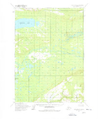
1954 Map of Lake Clark D-5
USGS Topo · Published 1978About this map
Whitefish Lake dominates the northwest corner of this sub-arctic landscape, serving as a primary hydrologic feature in a region defined by its complex network of waterways. The Mulchatna River winds through the central portion of the quadrangle, collecting drainage from numerous unnamed ponds and tributaries. In the south, the terrain rises toward the Hills, where higher elevations are marked by points such as Summit and Quana.
Find a feature on this map
10 named features on this map. Tap any name to fly to it.
Don’t see what you’re looking for? This feature index may not catch every label — zoom into the map to look around manually.
Map Details
Editions of this 1954 Lake Clark D-5 Map
2 editions found
Other maps of this area

1946 · Lake Clark
USGS Topo · 1:250,000

1951 · Lake Clark
USGS Topo · 1:250,000

1951 · Lime Hills
USGS Topo · 1:250,000

1954 · Lake Clark C-6
USGS Topo · 1:63,360

1954 · Lime Hills A-5
USGS Topo · 1:63,360

1954 · Lake Clark C-4
USGS Topo · 1:63,360

1954 · Lime Hills A-4
USGS Topo · 1:63,360

1954 · Lake Clark D-5
USGS Topo · 1:63,360

1954 · Lake Clark C-5
USGS Topo · 1:63,360

1954 · Lake Clark D-4
USGS Topo · 1:63,360