
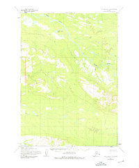
1954 Map of Lime Hills A-5
USGS Topo · Published 1965About this map
The Stony River winds through this interior Alaskan wilderness, as documented by the Army Map Service using aerial photography from the 1950s. The landscape is defined by the complex hydrology of the Lime Hills, where major glacial tributaries like Underhill Creek and Rock Creek feed into the primary river system. This survey represents a remote region largely untouched by permanent settlement or infrastructure, showing the natural state of the terrain before later developments. Notable landmarks include the expansive Hidden River Lake in the north and the southern drainage of Can Creek. The map provides a detailed view of the alluvial patterns and high-altitude contours of this subarctic environment during a period of intensive USGS mapping across the Alaska Territory.
Find a feature on this map
5 named features on this map. Tap any name to fly to it.
Don’t see what you’re looking for? This feature index may not catch every label — zoom into the map to look around manually.
Map Details
Editions of this 1954 Lime Hills A-5 Map
2 editions found
Other maps of this area

1946 · Lake Clark
USGS Topo · 1:250,000

1951 · Lake Clark
USGS Topo · 1:250,000

1951 · Lime Hills
USGS Topo · 1:250,000

1954 · Lime Hills B-4
USGS Topo · 1:63,360

1954 · Lime Hills A-4
USGS Topo · 1:63,360

1954 · Lime Hills B-5
USGS Topo · 1:63,360

1954 · Lake Clark D-5
USGS Topo · 1:63,360

1954 · Lake Clark D-4
USGS Topo · 1:63,360

1954 · Lime Hills A-6
USGS Topo · 1:63,360
1954 · Lake Clark D-6
USGS Topo · 1:63,360