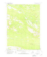
1954 Map of Lime Hills A-5
USGS Topo · Published 1976About this map
Stony River winds through this interior Alaskan landscape, characterized by significant elevation changes and glacial water systems as documented in the mid-1950s. The hydrography is defined by major tributaries including Underhill Creek, Rock Creek, and Can Creek, which drain the surrounding high ground. Tucked away in the northern half of the quadrangle, Hidden River Lake serves as a prominent landmark in an area otherwise dominated by unnamed ridges and valleys. While the map is devoid of established settlements, several named high points like Owens, Skeeter, Tela, and View provide essential orientation for navigation in this wilderness. This edition incorporates 1975 minor revisions to topography originally captured by the Army Map Service, reflecting the Bureau of Land Management's predetermined land lines for this unsurveyed territory.
Find a feature on this map
9 named features on this map. Tap any name to fly to it.
Don’t see what you’re looking for? This feature index may not catch every label — zoom into the map to look around manually.
Map Details
Editions of this 1954 Lime Hills A-5 Map
2 editions found
Other maps of this area

1946 · Lake Clark
USGS Topo · 1:250,000

1951 · Lake Clark
USGS Topo · 1:250,000

1951 · Lime Hills
USGS Topo · 1:250,000

1954 · Lime Hills A-5
USGS Topo · 1:63,360

1954 · Lime Hills B-4
USGS Topo · 1:63,360

1954 · Lime Hills A-4
USGS Topo · 1:63,360

1954 · Lime Hills B-5
USGS Topo · 1:63,360

1954 · Lake Clark D-5
USGS Topo · 1:63,360

1954 · Lake Clark D-4
USGS Topo · 1:63,360

1954 · Lime Hills A-6
USGS Topo · 1:63,360