
1954 Map of Lime Hills A-6
USGS Topo · Published 1968About this map
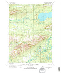
The Stony River cuts through the northern reaches of this Alaskan interior landscape, where a cluster of Cabins suggests a small pocket of human activity amidst the wilderness. To the west, the water of Salmon Berry Lake sits in a basin near the prominence of Side. The terrain is defined by dramatic elevations and drainage systems, including the confluence of Hook Creek and Can Creek which flow through the central and southern valleys. Landmarks like Whitefish SE Base in the southeast and named peaks such as Hook and Bear provide points of reference for the unmarked land lines predetermined by the Bureau of Land Management. This mid-century survey by the Army Map Service captures the area before modern infrastructure, documenting a landscape primarily accessible by river and trail.
Find a feature on this map
9 named features on this map. Tap any name to fly to it.
Don’t see what you’re looking for? This feature index may not catch every label — zoom into the map to look around manually.
Map Details
Editions of this 1954 Lime Hills A-6 Map
This is the sole edition of this map. No revisions or reprints were ever made.
Other maps of this area

1946 · Lake Clark
USGS Topo · 1:250,000

1951 · Lake Clark
USGS Topo · 1:250,000

1951 · Lime Hills
USGS Topo · 1:250,000

1954 · Lake Clark D-7
USGS Topo · 1:63,360

1954 · Lime Hills A-5
USGS Topo · 1:63,360

1954 · Lime Hills B-5
USGS Topo · 1:63,360

1954 · Lake Clark D-5
USGS Topo · 1:63,360

1954 · Lime Hills B-7
USGS Topo · 1:63,360

1954 · Lime Hills A-7
USGS Topo · 1:63,360
1954 · Lake Clark D-6
USGS Topo · 1:63,360