
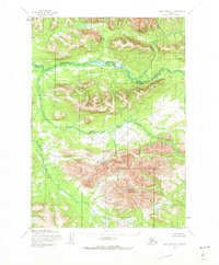
1954 Map of Lake Clark D-7
USGS Topo · Published 1964About this map
Hoholitna River and the Swift River define the intricate drainage patterns of this Alaskan interior landscape as it was documented in the mid-1950s. The topographic detail, produced through photogrammetric methods by the Army Map Service, focuses on the massive rise of Halfway Mountain in the southern portion of the quadrangle. This area of Lake and Peninsula is characterized by an absence of roads or trails, reflecting a wilderness state where travel was dictated entirely by river systems and natural terrain. The elevation contours reveal the transition from lowland river basins to the high, unnamed peaks that surround the distinctively named Halfway Mountain.
Find a feature on this map
4 named features on this map. Tap any name to fly to it.
Don’t see what you’re looking for? This feature index may not catch every label — zoom into the map to look around manually.
Map Details
Editions of this 1954 Lake Clark D-7 Map
2 editions found
Other maps of this area

1946 · Lake Clark
USGS Topo · 1:250,000

1951 · Lake Clark
USGS Topo · 1:250,000

1951 · Lime Hills
USGS Topo · 1:250,000

1954 · Lake Clark C-7
USGS Topo · 1:63,360

1954 · Lime Hills A-8
USGS Topo · 1:63,360

1954 · Lake Clark C-6
USGS Topo · 1:63,360

1954 · Lake Clark C-8
USGS Topo · 1:63,360

1954 · Lake Clark D-8
USGS Topo · 1:63,360

1954 · Lime Hills A-7
USGS Topo · 1:63,360

1954 · Lime Hills A-6
USGS Topo · 1:63,360