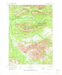
1954 Map of Lake Clark D-7
USGS Topo · Published 1973About this map
Halfway Mountain dominates the southern portion of this interior Alaskan landscape, providing a massive physical anchor for the surrounding river systems. The Hoholitna River meanders across the northern and central sections, following a complex path through the valley floors before turning north. This 1950s-era topography, based on aerial photographs from the Army Map Service and the U.S. Geological Survey, reveals a wilderness entirely devoid of roads or trails. Instead, the geography is defined by drainage patterns like Gnat Creek and McKinley Creek, which flow through unsurveyed lands predetermined by the Bureau of Land Management. The lack of human infrastructure highlights the territory's character as an untouched interior corridor where topographic elevation and watercourses were the only established landmarks.
Find a feature on this map
4 named features on this map. Tap any name to fly to it.
Don’t see what you’re looking for? This feature index may not catch every label — zoom into the map to look around manually.
Map Details
Editions of this 1954 Lake Clark D-7 Map
2 editions found
Other maps of this area

1946 · Lake Clark
USGS Topo · 1:250,000

1951 · Lake Clark
USGS Topo · 1:250,000

1951 · Lime Hills
USGS Topo · 1:250,000

1954 · Lake Clark C-7
USGS Topo · 1:63,360

1954 · Lime Hills A-8
USGS Topo · 1:63,360

1954 · Lake Clark C-6
USGS Topo · 1:63,360

1954 · Lake Clark C-8
USGS Topo · 1:63,360

1954 · Lake Clark D-8
USGS Topo · 1:63,360

1954 · Lake Clark D-7
USGS Topo · 1:63,360

1954 · Lime Hills A-7
USGS Topo · 1:63,360