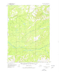
1954 Map of Lake Clark C-5
USGS Topo · Published 1977About this map
The Bonanza Hills dominate the northern landscape of this interior Alaskan territory, a region defined by a complex network of glacial and mountain streams during the mid-1950s. The Chilikadrotna River flows through the lower half of the quadrangle, joined by the Little Mulchatna River near the southeastern corner. This area shows no established roads or permanent settlements at the time of the survey, reflecting the remote nature of the Lake Clark region. Waterways serve as the primary landmarks, with Bonanza Creek and its many tributaries, including Synneva Creek and Caribou Creek, carving through the high terrain. The map captures a pristine state of the watershed before modern shifts, emphasizing the natural drainage patterns of Ptarmigan Creek and Victoria Creek.
Find a feature on this map
11 named features on this map. Tap any name to fly to it.
Don’t see what you’re looking for? This feature index may not catch every label — zoom into the map to look around manually.
Map Details
Editions of this 1954 Lake Clark C-5 Map
2 editions found
Other maps of this area

1946 · Lake Clark
USGS Topo · 1:250,000

1951 · Lake Clark
USGS Topo · 1:250,000

1954 · Lake Clark C-6
USGS Topo · 1:63,360

1954 · Lake Clark C-4
USGS Topo · 1:63,360

1954 · Lake Clark B-5
USGS Topo · 1:63,360

1954 · Lake Clark D-5
USGS Topo · 1:63,360

1954 · Lake Clark C-5
USGS Topo · 1:63,360

1954 · Lake Clark B-4
USGS Topo · 1:63,360

1954 · Lake Clark D-4
USGS Topo · 1:63,360

1954 · Lake Clark B-6
USGS Topo · 1:63,360