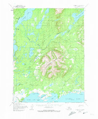
1954 Map of Iliamna D-5
USGS Topo · Published 1973About this map
Nondalton and Fish Village anchor the western edge of this Alaskan landscape, situated along the Newalen River as it flows south toward the massive expanse of Iliamna Lake. The terrain is dominated by the central massif of Roadhouse Mountain, which stands as a high divide between the river valley and the numerous bays of the lake's northern shore, including Northeast Bay and Whistlewing Bay.
Find a feature on this map
29 named features on this map. Tap any name to fly to it.
Don’t see what you’re looking for? This feature index may not catch every label — zoom into the map to look around manually.
Map Details
Editions of this 1954 Iliamna D-5 Map
2 editions found

Other maps of this area

1946 · Lake Clark
USGS Topo · 1:250,000

1951 · Lake Clark
USGS Topo · 1:250,000

1952 · Iliamna
USGS Topo · 1:250,000

1954 · Iliamna C-6
USGS Topo · 1:63,360

1954 · Lake Clark A-6
USGS Topo · 1:63,360

1954 · Iliamna C-5
USGS Topo · 1:63,360

1954 · Iliamna D-4
USGS Topo · 1:63,360

1954 · Lake Clark A-4
USGS Topo · 1:63,360

1954 · Iliamna C-4
USGS Topo · 1:63,360

1954 · Lake Clark A-5
USGS Topo · 1:63,360