Old Maps of Pedro Bay, Alaska for Hiking & Exploration
Hike through history with 4 historic maps of Pedro Bay. Explore old trails, ghost towns, and forgotten backroads — perfect for outdoor adventurers and local explorers.
- Rediscover forgotten places: Map out old mining camps, roads, and footpaths that no longer exist on modern maps.
- Layer with modern tools: Combine with LiDAR or satellite views to plan hikes through historical terrain.
- Made for exploration: Popular among hikers, overlanders, and local history lovers.
Use these maps to find adventure and explore the hidden past of Pedro Bay.
Pedro Bay, AK maps
(4)- 1952 Map of Iliamna, 1953 Print
 1952 Iliamna1953 Print · USGSAlaska's interior and coastline meet in this early 1950s survey of the Lake Iliamna region. Researchers can trace remote settlements and camps such as Fish Village, Old Iliamna (Aband), and Hammerly Camp at the edge of the Katmai National Monument.4 unique versions available
 - 1954 Map of Iliamna D-3, 1965 Print
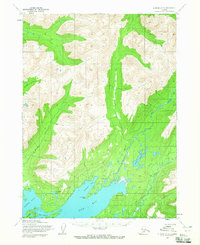 1954 Iliamna D-31965 Print · USGSCoastal settlements and river systems near Lake Iliamna are documented in the mid-1950s as they functioned before modern expansion. Researchers can trace the early layout of Pile Bay Village, Pedro Bay, and the inland trail used by locals.2 unique versions available
 - 1957 Map of Iliamna, 1965 Print
 1957 Iliamna1965 Print · USGSSouthwestern Alaska in the late fifties centers on the massive waters of Iliamna Lake and its surrounding villages. Trace family roots and old routes at Old Roadhouse, Newhalen, and the Kamishak (Site) near the edge of Katmai National Monument.7 unique versions available
 - 2018 Map of Iliamna D-3 SW, 2018 Print
 2018 Iliamna D-3 SW2018 Print · USGSThe northern shores of Iliamna Lake are captured here in the early twenty-first century, centered on the settlement of Pedro Bay. Local researchers can trace the reach of Airport Road or locate geographic landmarks like Porcupine Island and Lonesome Bay.
End of results
Showing maps 1-4 of 4
Frequently asked questions
- What are the different types of historical maps available for Pedro Bay?
- What is the oldest map of Pedro Bay?
- Where can I purchase historical maps of Pedro Bay for my home or office?
- Where can I download high-res historical maps of Pedro Bay?
- Are there historical topographic maps available for Pedro Bay?
- Is there historical aerial imagery available for Pedro Bay?
- Where are historical maps of Pedro Bay sourced from?