1900s (20th Century) Maps of Montana, Alaska
Explore 8 historic maps of Montana from the 1900s (20th Century). These maps offer a rare glimpse into what life looked like during the 1900s — showing old roads, neighborhoods, homes, and landmarks that have changed or disappeared over time.
Whether you're researching your family's past, planning a metal detecting trip, or studying how Montana's landscape evolved across the 1900s, these high-resolution maps are a powerful tool for exploring the history of this region.
- Focus on a specific era: All maps on this page are from the 1900s, giving you a focused view of this time period.
- See what’s changed: Compare century-old streets, trails, and buildings to today's modern landscape using overlays and satellite layers.
- Research with precision: Use these maps for genealogy, historical research, land use analysis, or educational projects.
- View, download, or print: Maps are fully viewable online in high resolution, and can be downloaded or printed for your own records.
Start exploring Montana's history through authentic maps from the 1900s. This is your window into the past.
Montana, AK maps
(8)- 1950 Map of Talkeetna, 1954 Print
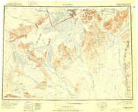
 1950 Talkeetna1954 Print · USGSThe Susitna Valley and the foothills of the Alaska Range appear in this mid-century survey as a frontier of remote lodges and rail-side outposts. You can trace the path of The Alaska Railroad through Talkeetna and locate vanished settlements like Sunflower.2 unique versions available
 - 1951 Map of Talkeetna
 1951 Talkeetna1951 Print · USGSInterior Alaska in the early fifties shows a wilderness being opened by the Alaska Railroad and bush aviation. You can trace early backcountry outposts like Chelatna Lodge, the riverside community of Talkeetna, and the high peaks of Mount Mc Kinley National Park.
 - 1952 Map of Talkeetna A-1
 1952 Talkeetna A-11952 Print · USGSThe Susitna River valley comes into focus during the early 1950s as the rail line connected remote interior outposts. Genealogists and historians can trace the early footprints of Sunshine and Montana, alongside the routes of The Alaska Railroad and Question Creek.2 unique versions available
 - 1958 Map of Talkeetna A-1, 1961 Print
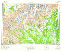
 1958 Talkeetna A-11961 Print · USGSThe Susitna Valley in the late fifties was a landscape of rail outposts and river crossings centered on the Alaska Railroad. Local historians can trace early transportation routes like the Tractor Trail near Sunshine or locate family-named features like Rockys Lakes and Parker.5 unique versions available
 - 1958 Map of Talkeetna, 1964 Print
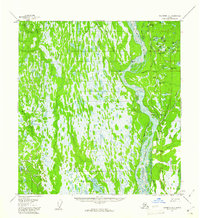
 1958 Talkeetna1964 Print · USGSThe Susitna Valley and Alaska Range meet in this mid-century survey of the rugged interior during a period of steady rail expansion. Historians can trace the Old Iditarod Trail, remote settlements like Collinsville, and the infrastructure of the Alaska Railroad.5 unique versions available
 - 1965 Map of Talkeetna
 1965 Talkeetna1965 Print · USGSAlaska's interior wilderness meets the steel of the Alaska Railroad during the mid-1960s. Genealogists and historians can trace remote settlements and cabins like Petersville, Collinsville, and the Sexton House tucked between the Alaska Range and the Yentna River.
 - 1987 Map of Talkeetna A-1 SE
 1987 Talkeetna A-1 SE1987 Print · USGSThe Susitna Valley in the early 1980s was a landscape defined by the braided Susitna River and the vital corridor of The Alaska Railroad. Researchers can trace the settlement at Montana and locate local landmarks like the Landing Strip and Trapper Lake.
 - 1994 Map of Talkeetna A-1, 2002 Print
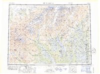
 1994 Talkeetna A-12002 Print · USGSThe Susitna River valley in the mid-1990s shows a landscape defined by the George Parks Highway and a network of interior trails. Researchers can trace remote settlements and unique local landmarks like Section House, the Birch Creek Slough, and Question Lake.
End of results
Showing maps 1-8 of 8
Frequently asked questions
- What are the different types of historical maps available for Montana?
- What is the oldest map of Montana?
- Where can I purchase historical maps of Montana for my home or office?
- Where can I download high-res historical maps of Montana?
- Are there historical topographic maps available for Montana?
- Is there historical aerial imagery available for Montana?
- Where are historical maps of Montana sourced from?